Single-Pass Drone Video to Accurate 3D Model Generation System (SIH Problem Statement 26158)
Live Command Center · Presentation · Demo · Setup · Requirements checklist
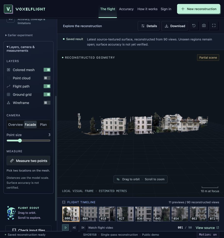
Actual source-textured reconstruction. Georeferenced to WGS 84 / UTM 32N with 518,786 point observations.
| Field | Project |
|---|---|
| Product | AIRIS (Aerial Intelligence for Reconstruction and Avian Surveillance) |
| PS ID | SIH26158 |
| PS Title | Single-Pass Drone Video to Accurate 3D Model Generation System |
| Organisation | National Technical Research Organisation |
| Category | Software |
| Theme | Drone / Robotics / Computer Vision |
| Registered Team | Awaiting confirmation; see team details |
Conventional 3D photogrammetric mapping requires multiple drone passes, extensive overlap grids (≥80%), and lengthy ground station processing. In critical disaster response, rapid infrastructure inspection, and defense reconnaissance, only one continuous single-pass video is available.
Problem Statement 26158 challenges solutions to generate metric-accurate, georeferenced 3D terrain and structural models from a moving UAV's single-pass video, GPS coordinates, and flight metadata, exporting standardized GIS point clouds and textured 3D meshes.
AIRIS integrates pretrained multi-view geometry, visual camera pose graph optimization, and sensor telemetry fusion (GNSS + Barometric Altitude):
DRONE VIDEO
  → FRAME EXTRACTION
  → CAMERA / FLIGHT TRAJECTORY
  → AI RECONSTRUCTION
  → GEOREFERENCING (WGS 84 / UTM 32N)
  → 3D POINT CLOUD (518K points)
  → 3D MESH (646K triangles)
  → TEXTURE (Source Photographic Reprojection)
  → TERRAIN / STRUCTURE ANALYSIS
  → MEASUREMENT & INTELLIGENCE
  → EXPORT (GLB, PLY, LAS, GeoTIFF DSM, JSON)
The primary application is an interactive 3D Geospatial Command Center:
.PLY (518,786 points, visual frame) and .LAS (UTM 32N georeferenced)..GLB (source-textured surface) and .OBJ (Wavefront CAD format)..TIF (GeoTIFF Digital Surface Model - DSM)..JSON (complete quantitative verification report).| Layer | Implementation |
|---|---|
| Command Center UI | HTML5, Vanilla CSS, JavaScript ES Modules, Three.js, Vite |
| Hosting & Auth | Modern Web Gateway & Firebase Authentication (Google SSO, OAuth) |
| Ingestion & Contracts | Python 3.10+, FastAPI, NumPy, SciPy |
| Multi-View Geometry | MapAnything, MASt3R-SLAM, COLMAP, Open3D |
| Geodesy & GIS | pyproj (WGS 84 / UTM 32N), laspy, rasterio, trimesh |
# Clone repository
git clone https://github.com/mouryas-aiml/AIRIS.git
cd AIRIS/viewer

# Install frontend dependencies
npm install

# Run automated verification test suite (72 unit and integration tests)
npm test

# Build production bundle
npm run build
Developed for Smart India Hackathon (SIH 2026). Dataset references credit Zurich Urban MAV and affiliated open-source computer vision libraries.
Single-Pass Drone Video to Accurate 3D Model Generation System (SIH Problem Statement 26158)
Live Command Center · Presentation · Demo · Setup · Requirements checklist
Actual source-textured reconstruction. Georeferenced to WGS 84 / UTM 32N with 518,786 point observations.
| Field | Project |
|---|---|
| Product | AIRIS (Aerial Intelligence for Reconstruction and Avian Surveillance) |
| PS ID | SIH26158 |
| PS Title | Single-Pass Drone Video to Accurate 3D Model Generation System |
| Organisation | National Technical Research Organisation |
| Category | Software |
| Theme | Drone / Robotics / Computer Vision |
| Registered Team | Awaiting confirmation; see team details |
Conventional 3D photogrammetric mapping requires multiple drone passes, extensive overlap grids (≥80%), and lengthy ground station processing. In critical disaster response, rapid infrastructure inspection, and defense reconnaissance, only one continuous single-pass video is available.
Problem Statement 26158 challenges solutions to generate metric-accurate, georeferenced 3D terrain and structural models from a moving UAV's single-pass video, GPS coordinates, and flight metadata, exporting standardized GIS point clouds and textured 3D meshes.
AIRIS integrates pretrained multi-view geometry, visual camera pose graph optimization, and sensor telemetry fusion (GNSS + Barometric Altitude):
DRONE VIDEO
  → FRAME EXTRACTION
  → CAMERA / FLIGHT TRAJECTORY
  → AI RECONSTRUCTION
  → GEOREFERENCING (WGS 84 / UTM 32N)
  → 3D POINT CLOUD (518K points)
  → 3D MESH (646K triangles)
  → TEXTURE (Source Photographic Reprojection)
  → TERRAIN / STRUCTURE ANALYSIS
  → MEASUREMENT & INTELLIGENCE
  → EXPORT (GLB, PLY, LAS, GeoTIFF DSM, JSON)
The primary application is an interactive 3D Geospatial Command Center:
.PLY (518,786 points, visual frame) and .LAS (UTM 32N georeferenced)..GLB (source-textured surface) and .OBJ (Wavefront CAD format)..TIF (GeoTIFF Digital Surface Model - DSM)..JSON (complete quantitative verification report).| Layer | Implementation |
|---|---|
| Command Center UI | HTML5, Vanilla CSS, JavaScript ES Modules, Three.js, Vite |
| Hosting & Auth | Modern Web Gateway & Firebase Authentication (Google SSO, OAuth) |
| Ingestion & Contracts | Python 3.10+, FastAPI, NumPy, SciPy |
| Multi-View Geometry | MapAnything, MASt3R-SLAM, COLMAP, Open3D |
| Geodesy & GIS | pyproj (WGS 84 / UTM 32N), laspy, rasterio, trimesh |
# Clone repository
git clone https://github.com/mouryas-aiml/AIRIS.git
cd AIRIS/viewer

# Install frontend dependencies
npm install

# Run automated verification test suite (72 unit and integration tests)
npm test

# Build production bundle
npm run build
Developed for Smart India Hackathon (SIH 2026). Dataset references credit Zurich Urban MAV and affiliated open-source computer vision libraries.