
QGIS plugin to use Valhalla for routing, isochrones, matrices & expansion.
Python
30
174 commits
updated Sep 22, 2026
README


QGIS Plugin for the Valhalla routing engine.
[!NOTE] This plugin supports both QGIS v3.x (on
qgis-v3branch) & v4.x (onmaster). The plugin's release series 6.x is reserved for QGIS3, series >=7.x for QGIS4.
It features:
- UI & processing algorithms to routing, isochrones, matrix & expansion endpoints for
pedestrian,bicycle,car,truck&motorcycle - (linux-x86_64 & macos-arm64 only) all local calculations after installing
pyvalhallawith the full flexibility of local Valhalla processes:- start a local server while reading from remote graphs, e.g. a tar file on some server (only support HTTP basic auth)
- build your own graph from a OSM PBF file
- support for most1 of Valhalla costing options in both UI & processing algorithms for all endpoints, e.g.
- time-dependent routing
- exclude polygons to avoid user-defined areas
- and various other costing options
- support for multiple Valhalla servers, the public server and
localhostare preconfigured - get extended graph information from the Valhalla server:
- load the graph extent from a given instance (usually
localhost) as a polygon layer - check for admins & timezone DBs
- print Valhalla server version
- print date of last graph update
- load the graph extent from a given instance (usually
[!NOTE] Starting with
v3.0.0this plugin had a complete re-write from scratch. Previously it was loosely based on one of my ex-plugins ORS Tools, but that design has a quite a few shortcomings in terms of UX and aesthetics. The biggest problem is that the dialogs are huge and one can't properly access both the map canvas and the plugin at the same time. Starting withv3.0.0it's a docked plugin, i.e. arranging itself as a proper panel thanks to the awesome Qt/QGIS APIs.
How To
[!NOTE] Waypoints can now be controlled in the map's context menu (right-click in the map).
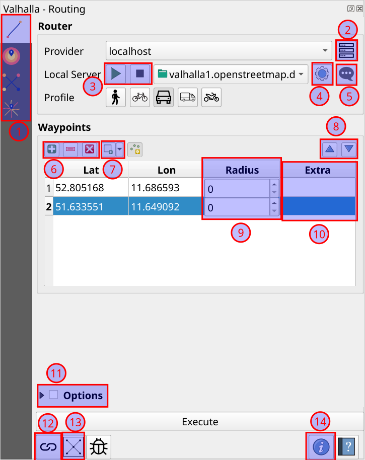
Routing UI
-
Select the endpoint/action to "Execute". Note that some endpoints expect multiple waypoints.
-
Manage the servers which are shown in the "Provider" drop-down
-
Start or stop a Valhalla service on
localhostwith the local graph shown in the dropdown menu -
Manage settings for the local setup, see "Settings UI"
-
Watch logs for the local Valhalla service
-
Add/remove/clear waypoints in the table:
- to add waypoints, click the "add" button and then in the map canvas. To end the adding session, either double-click in the map canvas or click the "add" button again.
- to remove single/multiple waypoints, click rows in the waypoints table before clicking the "remove" button.
- the "clear" button will remove all waypoints from the table
-
Multiple alternatives to add waypoints to the table:
- "From Point Layer": parses waypoints from the features of a user-specified point layer
- "From Valhalla JSON": parses waypoints from a Valhalla
locationsrequest array (TODO: #27) - "From OSRM URL": parses waypoints from a OSRM GET request URL, also sets
bearingetc in the "Extra" column
-
Moves the selected waypoint rows up & down, also updates the "Valhalla waypoints" annotation layer
-
Set a radius for each waypoint which will snap more roads
-
Set extra Valhalla waypoint properties in URL query parameter form (i.e.
k1=v1&k2=v2), e.g.waiting=1800&date_time=2025-07-25T09:00 -
Additional costing options to influence the path finding for any endpoint
-
View the full most recent request, mostly useful when reporting issues, or debugging.
-
Check the remote graph for admin & timezone DBs (they should exist) and loads the graph extent of the currently set Valhalla server as a polygon layer (if available).
-
Some information about the plugin and (if available) the currently set Valhalla server.
Settings UI
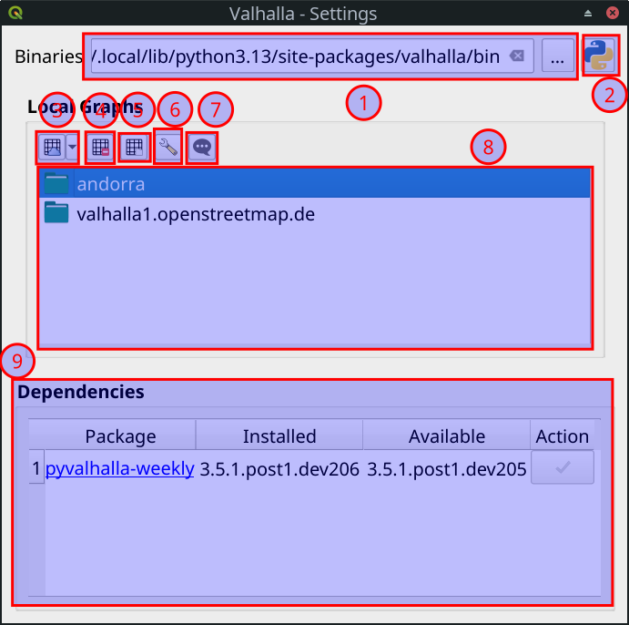
- Change the parent directory of the local Valhalla executables; useful mostly for debugging
- Defaults the binary directory back to the Python bindings one
- Lets the user add graphs from mulitple sources:
- from a tar file, e.g. built with one of Valhalla's docker images
- from a URL, which could be a remote tar file or graph directory; also support HTTP basic auth
- from a OSM PBF file, which will build the graph from scratch
- Remove a local graph
- Change the directory or disk for local graphs
- Edit the Valhalla configuration which will control both the local graph build and the local service
- View the local graph build logs
- List of locally registered graphs available for
localhost - A list of dependencies; currently only
pyvalhallais supported. After plugin installation you can install the package from here. On QGIS startup it'll check if there's a new version available and let you update.
Notes on localhost
[!NOTE] Integration of
pyvalhallaworks on Linux x64, OSX arm64 & Windows x64 (Windows sincepyvalhalla3.9.0, which finally ships a workingvalhalla_service.exe, see https://github.com/valhalla/valhalla/issues/5314).
The main distinguishing features of this plugin (compared to other routing plugins) is the ability to:
- run a local and fully configurable routing server
- and even build a custom Valhalla graph from your own OSM PBF to use that as input for the local Valhalla server
both without any kind of additional setup, all taken care of straight from the plugin's UI. I added this feature mainly because:
- our public FOSSGIS server is both rate-limited and distance-limited and some use cases require more than is publicly available
- lots of QGIS users might not be very comfortable or are even prohibited to set up a local Valhalla server via e.g. docker
While the fully integrated solution tries to install the Python package pyvalhalla for you, there are probably situations where that will fail in some way (note, this plugin is only CI tested on Linux). In those cases, you can still do the following:
- if you have the skills and/or permission, set up a local Valhalla server using one of our docker images
- even if the Python package installation fails, you can still use it if you have permissions to download from PyPI **and
** permissions to execute "random" programs:
- download the latest
pyvalhallawheel for your platform - the wheel is really just a ZIP file, so you can unzip it to wherever you want
- go to the plugin's "local server" settings and point the "Binaries" path to
<unzipped_pyvalhalla_path>/bin - now you should be able to use the fully local setup
- download the latest
Test
Local
Since this plugin is pretty flexible, so the tests need to be too:
-
tests/test_localhost_docker: needs an external local service running, e.g.docker start valhalla-router # or if it doesn't exist yet # docker run -dt --name valhalla-router -p 8002:8002 -v $PWD/tests/data:/custom_files -e server_threads=2 -e tileset_name=andorra-tiles ghcr.io/valhalla/valhalla-scripted:latest # "uninstall" python package if it's installed rm -r /home/nilsnolde/.local/share/QGIS/QGIS4/profiles/default/valhalla/pyvalhalla QT_QPA_PLATFORM=offscreen python -m coverage run --append -m unittest discover -s tests/test_localhost_docker -t . -
tests/test_localhost_plugin: e.g.# stop docker container if it's running docker stop valhalla-router # test will download & install pyvalhalla QT_QPA_PLATFORM=offscreen python -m coverage run --append -m unittest discover -s tests/test_localhost_plugin -t .
Docker
In CI we run the tests with the QGIS docker image, have a look there.
Release
To keep unintended files out of the zip, use the following:
find valhalla \
  \( -type d -name '__pycache__' \
     -o \( -path 'valhalla/third_party/routingpy/*' \
           ! -path 'valhalla/third_party/routingpy/routingpy' \
           ! -path 'valhalla/third_party/routingpy/routingpy/*' \) \
  \) -prune -o -type f -print \
| zip -r dist/valhalla_4.0.0.zip -@
History
Without going into too much detail, this plugin had once a much wider scope. Back when I was still running GIS-OPS, I was a bit obsessed with providing an alternative to ESRI's network analyst, one of the last areas where QGIS is very very far behind ESRI. That's a crazy huge task, especially including all those optimization algorithms. However, together with @chrstnbwnkl we actually did come a pretty long way:
- support for both Valhalla & OSRM
- optimization support
spoptandpyvroomin the plugin UI - support for all local calculations via
We were also planning to open a web shop where you could buy Valhalla & OSRM graphs right from QGIS and load them locally in a heartbeat. The idea was grand and a lot of OSS was being released as the result of it, e.g. the python bindings to Valhalla & OSRM and Windows support for pyvroom. Sadly the work to get there was grand as well and we never ended up releasing the full plugin.
The current Valhalla plugin still has all the source code though, mostly just commented out. In case anyone ever feels the urge to rival ESRI Network Analyst, please contact me on nilsnolde+github@proton.me.
I also should mention that @chrstnbwnkl was quite heavily involved in the initial development as an employee in GIS-OPS times. However, some accidental git failures almost entirely wiped out his initial contributions.
Footnotes
-
Some costing options make little sense, e.g. transit, some others we didn't get around to yet. Valhalla is also under constant development, we might miss a few recently added ones. ↩
Contributors



Similar repos


Languages
Python
94.2%
QML
5.5%
QGIS plugin to use Valhalla for routing, isochrones, matrices & expansion.
Python
30
174 commits
updated Sep 22, 2026
README
QGIS Plugin for the Valhalla routing engine.
[!NOTE] This plugin supports both QGIS v3.x (on
qgis-v3branch) & v4.x (onmaster). The plugin's release series 6.x is reserved for QGIS3, series >=7.x for QGIS4.
It features:
- UI & processing algorithms to routing, isochrones, matrix & expansion endpoints for
pedestrian,bicycle,car,truck&motorcycle - (linux-x86_64 & macos-arm64 only) all local calculations after installing
pyvalhallawith the full flexibility of local Valhalla processes:- start a local server while reading from remote graphs, e.g. a tar file on some server (only support HTTP basic auth)
- build your own graph from a OSM PBF file
- support for most1 of Valhalla costing options in both UI & processing algorithms for all endpoints, e.g.
- time-dependent routing
- exclude polygons to avoid user-defined areas
- and various other costing options
- support for multiple Valhalla servers, the public server and
localhostare preconfigured - get extended graph information from the Valhalla server:
- load the graph extent from a given instance (usually
localhost) as a polygon layer - check for admins & timezone DBs
- print Valhalla server version
- print date of last graph update
- load the graph extent from a given instance (usually
[!NOTE] Starting with
v3.0.0this plugin had a complete re-write from scratch. Previously it was loosely based on one of my ex-plugins ORS Tools, but that design has a quite a few shortcomings in terms of UX and aesthetics. The biggest problem is that the dialogs are huge and one can't properly access both the map canvas and the plugin at the same time. Starting withv3.0.0it's a docked plugin, i.e. arranging itself as a proper panel thanks to the awesome Qt/QGIS APIs.
How To
[!NOTE] Waypoints can now be controlled in the map's context menu (right-click in the map).
Routing UI
-
Select the endpoint/action to "Execute". Note that some endpoints expect multiple waypoints.
-
Manage the servers which are shown in the "Provider" drop-down
-
Start or stop a Valhalla service on
localhostwith the local graph shown in the dropdown menu -
Manage settings for the local setup, see "Settings UI"
-
Watch logs for the local Valhalla service
-
Add/remove/clear waypoints in the table:
- to add waypoints, click the "add" button and then in the map canvas. To end the adding session, either double-click in the map canvas or click the "add" button again.
- to remove single/multiple waypoints, click rows in the waypoints table before clicking the "remove" button.
- the "clear" button will remove all waypoints from the table
-
Multiple alternatives to add waypoints to the table:
- "From Point Layer": parses waypoints from the features of a user-specified point layer
- "From Valhalla JSON": parses waypoints from a Valhalla
locationsrequest array (TODO: #27) - "From OSRM URL": parses waypoints from a OSRM GET request URL, also sets
bearingetc in the "Extra" column
-
Moves the selected waypoint rows up & down, also updates the "Valhalla waypoints" annotation layer
-
Set a radius for each waypoint which will snap more roads
-
Set extra Valhalla waypoint properties in URL query parameter form (i.e.
k1=v1&k2=v2), e.g.waiting=1800&date_time=2025-07-25T09:00 -
Additional costing options to influence the path finding for any endpoint
-
View the full most recent request, mostly useful when reporting issues, or debugging.
-
Check the remote graph for admin & timezone DBs (they should exist) and loads the graph extent of the currently set Valhalla server as a polygon layer (if available).
-
Some information about the plugin and (if available) the currently set Valhalla server.
Settings UI
- Change the parent directory of the local Valhalla executables; useful mostly for debugging
- Defaults the binary directory back to the Python bindings one
- Lets the user add graphs from mulitple sources:
- from a tar file, e.g. built with one of Valhalla's docker images
- from a URL, which could be a remote tar file or graph directory; also support HTTP basic auth
- from a OSM PBF file, which will build the graph from scratch
- Remove a local graph
- Change the directory or disk for local graphs
- Edit the Valhalla configuration which will control both the local graph build and the local service
- View the local graph build logs
- List of locally registered graphs available for
localhost - A list of dependencies; currently only
pyvalhallais supported. After plugin installation you can install the package from here. On QGIS startup it'll check if there's a new version available and let you update.
Notes on localhost
[!NOTE] Integration of
pyvalhallaworks on Linux x64, OSX arm64 & Windows x64 (Windows sincepyvalhalla3.9.0, which finally ships a workingvalhalla_service.exe, see https://github.com/valhalla/valhalla/issues/5314).
The main distinguishing features of this plugin (compared to other routing plugins) is the ability to:
- run a local and fully configurable routing server
- and even build a custom Valhalla graph from your own OSM PBF to use that as input for the local Valhalla server
both without any kind of additional setup, all taken care of straight from the plugin's UI. I added this feature mainly because:
- our public FOSSGIS server is both rate-limited and distance-limited and some use cases require more than is publicly available
- lots of QGIS users might not be very comfortable or are even prohibited to set up a local Valhalla server via e.g. docker
While the fully integrated solution tries to install the Python package pyvalhalla for you, there are probably situations where that will fail in some way (note, this plugin is only CI tested on Linux). In those cases, you can still do the following:
- if you have the skills and/or permission, set up a local Valhalla server using one of our docker images
- even if the Python package installation fails, you can still use it if you have permissions to download from PyPI **and
** permissions to execute "random" programs:
- download the latest
pyvalhallawheel for your platform - the wheel is really just a ZIP file, so you can unzip it to wherever you want
- go to the plugin's "local server" settings and point the "Binaries" path to
<unzipped_pyvalhalla_path>/bin - now you should be able to use the fully local setup
- download the latest
Test
Local
Since this plugin is pretty flexible, so the tests need to be too:
-
tests/test_localhost_docker: needs an external local service running, e.g.docker start valhalla-router # or if it doesn't exist yet # docker run -dt --name valhalla-router -p 8002:8002 -v $PWD/tests/data:/custom_files -e server_threads=2 -e tileset_name=andorra-tiles ghcr.io/valhalla/valhalla-scripted:latest # "uninstall" python package if it's installed rm -r /home/nilsnolde/.local/share/QGIS/QGIS4/profiles/default/valhalla/pyvalhalla QT_QPA_PLATFORM=offscreen python -m coverage run --append -m unittest discover -s tests/test_localhost_docker -t . -
tests/test_localhost_plugin: e.g.# stop docker container if it's running docker stop valhalla-router # test will download & install pyvalhalla QT_QPA_PLATFORM=offscreen python -m coverage run --append -m unittest discover -s tests/test_localhost_plugin -t .
Docker
In CI we run the tests with the QGIS docker image, have a look there.
Release
To keep unintended files out of the zip, use the following:
find valhalla \
  \( -type d -name '__pycache__' \
     -o \( -path 'valhalla/third_party/routingpy/*' \
           ! -path 'valhalla/third_party/routingpy/routingpy' \
           ! -path 'valhalla/third_party/routingpy/routingpy/*' \) \
  \) -prune -o -type f -print \
| zip -r dist/valhalla_4.0.0.zip -@
History
Without going into too much detail, this plugin had once a much wider scope. Back when I was still running GIS-OPS, I was a bit obsessed with providing an alternative to ESRI's network analyst, one of the last areas where QGIS is very very far behind ESRI. That's a crazy huge task, especially including all those optimization algorithms. However, together with @chrstnbwnkl we actually did come a pretty long way:
- support for both Valhalla & OSRM
- optimization support
spoptandpyvroomin the plugin UI - support for all local calculations via
We were also planning to open a web shop where you could buy Valhalla & OSRM graphs right from QGIS and load them locally in a heartbeat. The idea was grand and a lot of OSS was being released as the result of it, e.g. the python bindings to Valhalla & OSRM and Windows support for pyvroom. Sadly the work to get there was grand as well and we never ended up releasing the full plugin.
The current Valhalla plugin still has all the source code though, mostly just commented out. In case anyone ever feels the urge to rival ESRI Network Analyst, please contact me on nilsnolde+github@proton.me.
I also should mention that @chrstnbwnkl was quite heavily involved in the initial development as an employee in GIS-OPS times. However, some accidental git failures almost entirely wiped out his initial contributions.
Footnotes
-
Some costing options make little sense, e.g. transit, some others we didn't get around to yet. Valhalla is also under constant development, we might miss a few recently added ones. ↩
Similar repos
Contributors
Languages
Python
94.2%
QML
5.5%