Explore the aircraft above you, follow a flight across the map, or inspect traffic around an airport. SkyTrace combines live positions, recorded airport movements, route details and aircraft profiles in one responsive interface.
Open the public demo · Run locally · Data and privacy
AF1234 finds AFR1234), registration, type or airline, or find an airport by name, city, IATA or ICAO code.F-HBXA, N283VA, 3986E0) opens any airframe, even one that is not flying. A button loads the aircraft's recent flights on demand.?at=lat,lon,zoom) by URL (the native share sheet on phones). Recent airports, up to eight favourites, map filters and display preferences stay in your browser; the first visit follows your system light or dark setting.The same workflows are available on desktop and phone. Data coverage and enrichment depend on the providers; unknown routes and delayed feeds are labelled in the interface.
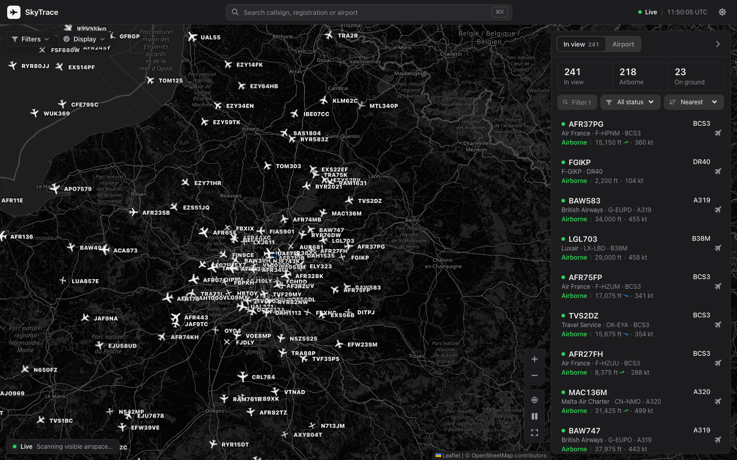
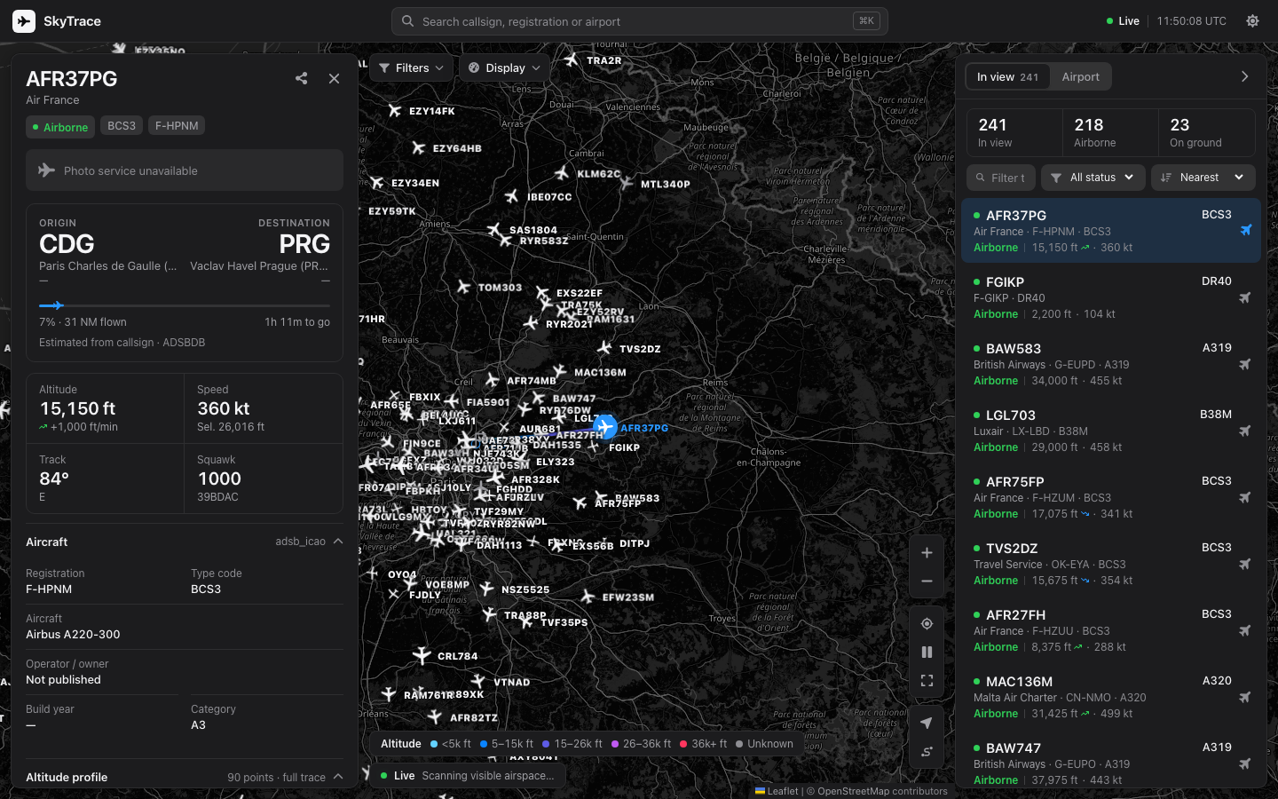
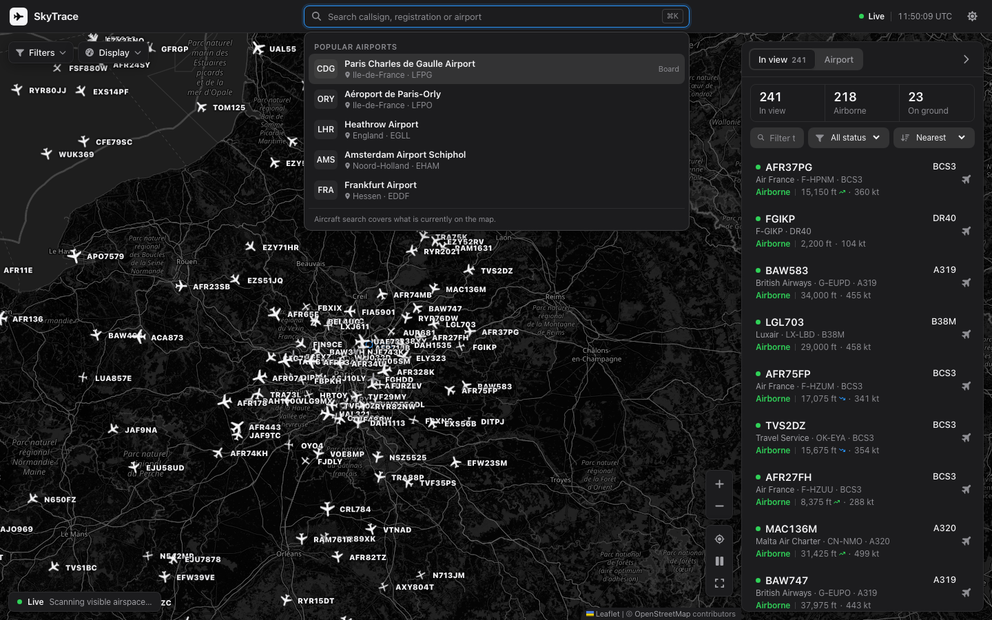
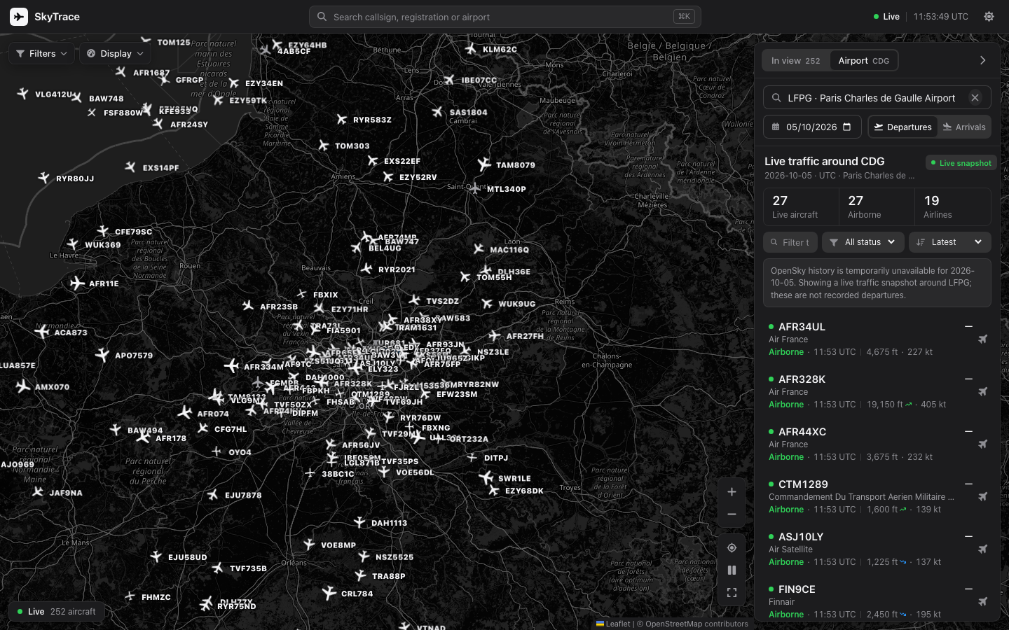
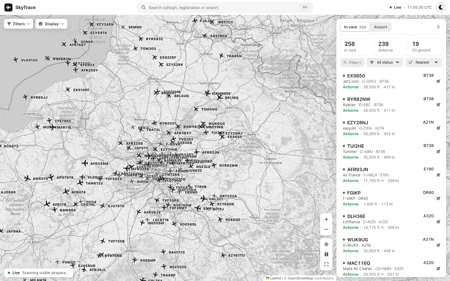
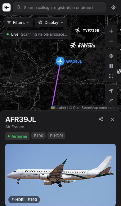
These are browser screenshots of the running site, captured on 5 October 2026 from the current local frontend connected to the public SkyTrace API. The maps use real OpenStreetMap tiles and the aircraft are live API responses. No traffic, map tiles or photos were generated for these images. Live positions and availability will differ when you open the demo.
| Key | Action |
|---|---|
⌘K, Ctrl K or / | Focus search |
↑, ↓, Enter | Navigate and select search or flight results |
F | Toggle following the selected aircraft |
R | Frame the selected route |
T | Switch between the dark and light map |
L | Show or hide surrounding aircraft labels |
P | Show or hide aircraft trails |
U | Switch between aviation and metric units |
? | Show the keyboard shortcuts |
Esc | Close the active search, menu, full map or flight detail |
http.server, Requests, python-dotenvThe Python server owns all OpenSky authentication. Credentials are never sent to the browser.
Requirements:
Install dependencies:
npm install
python3 -m pip install -r requirements-dev.txt
Create the local environment file:
cp .env.example .env
Then set both values in .env:
OPEN_SKY_CLIENT_ID=your_client_id
OPEN_SKY_CLIENT_SECRET=your_client_secret
Never commit .env. It is already ignored by Git.
Start the API server:
python3 server.py
In another terminal, start Vite:
npm run dev
Open http://localhost:5173. Vite proxies /api to the Python server at http://localhost:8000.
If local OpenSky credentials are unavailable, set SKYTRACE_API_ORIGIN=https://opensky-flight-tracking.vercel.app in .env.local. The frontend remains on localhost:5173 for Impeccable Live, while /api is proxied to the authenticated production backend. Do not put API secrets in this setting.
npm run build
python3 server.py
The server automatically serves dist/index.html and its hashed assets. Open http://localhost:8000.
npm run lint
npm run test
python3 -m pytest -q
npm run build
npm run test:e2e
Unit and E2E tests use deterministic API responses and do not consume OpenSky credits. To perform a live smoke test, configure .env, run both servers, and verify health, airport search, arrivals, departures, viewport traffic, and a flight track.
GET /api/healthGET /api/search-airports?q=...&limit=...GET /api/airportsGET /api/flights?airport=ICAO&date=YYYY-MM-DD&mode=departure|arrivalGET /api/fetch-flights?... — compatibility aliasGET /api/live-flights?lamin=...&lomin=...&lamax=...&lomax=...GET /api/flight-info?icao24=...&callsign=...GET /api/track?icao24=...&time=...The application stores only theme, units, display options (labels, airport markers, panel state, altitude and ground filters, list sorting; free-text filters last for the session), live-refresh preference, recent airports (which you can clear), and favorites in browser localStorage. No user account or personal flight history is created. Map tiles come from OpenStreetMap. Flight history comes from OpenSky; on Vercel, live positions use ADSB.lol with Airplanes.live as a fallback. Airframe history is free and keyless. OpenSky publishes dated copies of its aircraft database; scripts/build_aircraft_history.py compares eleven of them (November 2020 to August 2025) and stores each aircraft's changes of registration, owner and operator in data/aircraft-history/, so those are dated to a snapshot month and stop at the newest snapshot. For aircraft ever registered in the United States, scripts/build_faa_registry.py adds the FAA's public aircraft registry (data/faa-registry/): the current registration and every earlier one of the airframe with exact dates, city and state, and the export country. The FAA data keeps no street addresses, and individuals', partners' and co-owners' names are not stored: those registrations read "Private owner" (an organisation filter also applies to N-registered owners from OpenSky). The registered owner today comes from the keyless ADSBDB registry (cached a day). US registrations convert to their ICAO24 code arithmetically; other countries resolve through ADSBDB. Recent flights are one FlightAware page per tail, cached an hour and counted against the same budget below. Refresh the datasets by re-running the two scripts on newly downloaded files.
The scheduled board uses one FlightAware AeroAPI page (15 flights, $0.005) per airport and direction, only for the direction on screen, cached ten minutes in the function and at the Vercel CDN so every visitor of that airport shares it. Each function instance stops calling AeroAPI after SKYTRACE_AEROAPI_MONTHLY_PAGES (default 600, about $3 of the Personal tier's $5 monthly allowance) or SKYTRACE_AEROAPI_HOURLY_PAGES (default 60) pages; selected-aircraft lookups count against the same ceilings and reuse a flight the board already fetched. AeroAPI has no usage endpoint, so these per-instance counters are a safety net rather than an account-wide cap; /api/health reports them. The live airport board is built from ADS-B positions within 150 NM of the airport (one public-provider request per refresh) and each callsign's usual route from the adsb.lol route database. It is an observation, not a timetable: aircraft that have not switched on their transponder yet do not appear, and arrival times are estimated from distance and ground speed. Weather comes from the NOAA Aviation Weather Center (the nearest station within 50 km when the airport has no METAR), US delays from the FAA NAS Status feed, and runways and frequencies from the bundled OurAirports snapshot in data/airport-details.json (rebuild it with scripts/build_airport_details.py). The favoured runway is a wind-only estimate. Each source fails on its own, and a rate-limited board falls back to the authenticated feed, the map's recent snapshot, then its last good result, labelled as delayed. If OpenSky history is unavailable, an airport search returns a clearly labelled live snapshot around the airport so the map and list remain useful; it does not claim those aircraft are historical movements.
Origin and destination for historical records come from OpenSky. For a live aircraft, the selected callsign is resolved on demand through the ADSBDB callsign API and, when configured, the FlightAware AeroAPI connected to the Hermes flight-tracker skill. Both enrichments are cached briefly; a missing or disabled source leaves the route explicitly unknown. The selected hex code also gets a one-shot profile lookup from the ADS-B provider, including registration, type, operator and signal fields. Set SKYTRACE_ROUTE_LOOKUP_ENABLED=0 or SKYTRACE_FLIGHTAWARE_ENABLED=0 to disable either enrichment.
FlightAware data is fetched server-side with FLIGHTAWARE_AEROAPI_KEY; the key is never sent to the browser. A selected aircraft triggers at most one operational lookup per cache window, with failed lookups held for the retry window. The flight dock shows status, scheduled/estimated/actual times, delays, progress, gates, terminals, and filed route when the provider publishes them.
Live viewport requests use a short in-process cache, a small client request spacing, and a provider-aware refresh cadence. OpenSky state queries cost 1–4 credits based on bounding-box area; the default SKYTRACE_OPENSKY_DAILY_BUDGET=3000 targets 3,000 of the standard 4,000 daily credits and yields roughly 30/60/90/120-second polling for increasingly wide boxes. If the configured credentials are rejected, the private proxy can serve current boxes anonymously at a slower cadence sized for the 400-credit anonymous bucket; set OPEN_SKY_PROXY_ANONYMOUS_FALLBACK=0 to disable that path. The public ADS-B fallback respects the 250 NM point-endpoint limit by merging a bounded grid for wider viewports (SKYTRACE_LIVE_MAX_TILES, default 36), pacing cells 1.3 seconds apart by default, and lengthening its polling interval as the grid grows.
The production stack keeps OpenSky for recorded airport history and complete live bounding boxes when the private proxy is available, then uses ADSB.lol and Airplanes.live for resilient live coverage. A third public feed is not queried on every refresh: adding one would increase latency and could violate its fair-use rules. ADSB.fi is a useful optional source for a future controlled fallback, but its public endpoints are limited to one request per second and personal, non-commercial use.
For a materially faster and quota-free local setup, the most reliable option is a nearby ADS-B receiver running readsb/tar1090; the server can consume that local feed and use OpenSky only for history and enrichment. Check each provider's current terms before enabling commercial or high-frequency use: OpenSky REST API, OpenSky terms, ADSB.lol open data, and ADSB.fi limits.
The Alerts traffic tab requests global squawks 7500/7600/7700 from the open-source adsb.lol API. It refreshes only while that tab is open, once a minute, with a shared server/CDN cache. Feed failures are labelled unavailable rather than an empty sky. Complete callsigns can also be searched outside the map viewport; ticket flight numbers cannot always resolve alphanumeric ATC callsigns.
The selected flight's readsb trace supplies sampled emergency/priority codes and the observed change times, including a signal which has since cleared. The latest leg boundary, matching callsign and trace time prevent a previous flight's emergency being attached to the current one. ADS-B data does not establish medical or technical causes, and an absent code does not rule out an incident.
A diversion explicitly reported by the configured FlightAware source is labelled with that source and checked against the flight instance. An open-data alternative observes a sustained ground segment after airborne positions within 3 km of a catalogue airport, at least 30 km from the known planned destination. It is labelled Possible diversion / return to origin · ADS-B estimate, never confirmed; no inference is made from a heading change, taxiing alone, missing destination, historical selection or stale trace. The destination itself may come from a usual-callsign route, so geographic evidence remains provisional.
adsb.lol data is distributed under ODbL; its licence is separate from this repository's source-code licence. No scraping of AirNav Radar, new paid subscription or automated incident-cause claim is used.
MIT
Interface icons are from Font Awesome Free (solid set) by Fonticons, Inc., licensed under CC BY 4.0. Regenerate them with node scripts/build-icons.mjs <fontawesome-free-web-folder>.
Ticket flight numbers (AF1234) are matched to callsigns (AFR1234) with src/airlineCodes.ts, generated from the bundled OpenFlights airline list by python3 scripts/build_airline_codes.py. Only active airlines with both an IATA and an ICAO code are kept.
The map and airport board display observed traffic. No regional timetable integration is enabled: a planned-flight board needs a verified global provider. See provider research and metadata provenance.
The worldwide squawk feed shares requests per server instance, retries transient failures once, and backs off after provider errors or rate limits. A delayed last observation is retained for at most five minutes, explicitly dated, and cannot be selected as a current live alert. Degraded responses are not CDN-cached. The feed remains dependent on public receiver coverage; no code establishes the cause of an incident.
Flight details put the route, measurements and operations before photographs and reference history. On mobile, details replace the list sheet with a return action. Airport boards distinguish local scheduled, estimated and actual times; recorded history remains in UTC. Keyboard tabs, named aircraft markers, larger panel text and targeted reduced-motion behaviour support the same workflows across devices.
Aircraft photos are requested in the browser from Planespotters.net. When that service has no photo or cannot be reached, a photo may be shown from Wikimedia Commons only if its file title matches the aircraft registration exactly and its author and license are available. Commons results are marked as registration matches, with the author, license and original file page linked in the interface. No generic aircraft photo is substituted for a specific airframe.
Audit evidence and limitations: 13 October reliability and usability audit.
The second observation-integrity audit addresses matched operational route preference, historical-flight isolation, dated position observations, accessible time-scaled altitude inspection and expandable mobile details. Only the selected live trace refreshes automatically (every 90 seconds); failed refreshes retain the previous observations.
The drawer renders from the selected live state immediately. /api/flight-route?callsign=AFR123 resolves the usual route separately from the slower aircraft/operations profile, photo and registry requests. Each lookup is abortable and cached under its own identity. Route coordinates travel in the response; geometric progress is explicitly estimated, and a usual callsign route never supplies a confirmed arrival time. Unknown progress and absent optional fields are hidden.
/api/aircraft-enrichment?operator=AFR&type=A359®istration=F-HTYA returns optional cabin configurations from data/cabin-configurations.json. The catalogue has 34 published layouts spanning 33 operator/type pairs. All entries include a source, check date, class counts and a seat-information link. Some European short-haul cabins have a movable Business/Economy boundary; these show the total capacity and explain why the split cannot be stated. Match levels are operator_type, airframe or null. A registration alone cannot promote a fleet layout to an exact match: that requires an explicit registration assignment and an assignment source. The catalogue currently makes no exact-airframe claims. Missing operator/type pairs return an empty list. Published capacities are not live inventory or availability; retrofits and substitutions may differ.
The catalogue uses airline publications and AeroLOPA aircraft plans, with no paid API or request-time scraping. To extend it, verify the precise ICAO type/operator combination and class totals, attach the source and check date, and add amenities only where that source identifies them for this configuration. Never carry amenities across variants. data/aircraft-types.json supplies the shared fallback model names. Airline marks are loaded on demand from Kiwi's airline-image CDN for explicitly mapped ICAO operators and selected unique mappings from the bundled OpenFlights airline list (ODbL; operator codes may become outdated). The dated data/airline-logos.json catalogue contains 388 checked assets, with 364 enabled. Twenty generic aircraft placeholders and four images for the wrong code holder are excluded; Southwest, Cargolux and Smartwings use sourced local replacements. Availability of an image alone does not validate its brand identity. Unknown or failed logos fall back to a stable three-letter operator badge when an operator code is available, and carrier trademarks remain their owners' property. A selected aircraft's long dashed guide is a direct geographic line to the known destination, not an ATC route; when no destination is known, only a short heading projection is shown.
A dashed arrow on the selection projects the reported heading for two minutes (at most 40 km). It is not a destination or filed route. It is omitted for historical/ground aircraft, invalid heading/speed or fixes over 60 seconds old. Emergency queries retry transient failures, bypass stale upstream cache entries, and fall back to three individual squawk requests if the combined endpoint rejects the query or returns malformed/stale data. All three must succeed; a partial answer never claims an empty worldwide sky. Last-good snapshots expire after five minutes.
data/airline-code-corrections.json holds dated, sourced corrections to the historic OpenFlights table. Regenerate with python3 scripts/build_airline_codes.py; verify reproducibility without writing files with python3 scripts/build_airline_codes.py --check. Corrections replace the named IATA assignment and remove duplicate legacy aliases for the corrected ICAO operator. Search, ticket-number labels and airline logos consume the same generated table. The 2026-10-14 snapshot covers 363 usable rows from all 38 pages of the public IATA member directory, grouped into 362 assignments, plus two retained non-member corrections (364 assignments total). Shared/starred designators and entries without a valid ICAO code were skipped. This covers IATA members, not every operator worldwide. The same sourced names also enrich server responses; multiple operators sharing an IATA code retain distinct names.
Cabin classes and capacities appear before an optional, folded seat inventory. Each symbol represents one published seat; the grid does not reconstruct rows, aisles or available seats. Loading and errors are explicit, and a retry is available after a failed request. The inventory resets on aircraft selection; source and seat-map links remain available without expanding it. Altitude axes include dates when observations cross midnight UTC.
The new cabin/graph browser suite covers published data, empty and error states, keyboard inspection, both themes, 375/768/1440 px layouts and 200% text sizing. Live screenshots in the README are separate from deterministic browser checks; an automated real-tile visual baseline is still a future task.
Validation evidence: 14 October global quality audit.
Logo maintenance: python3 scripts/check_airline_logos.py validates the catalogue, sourced local files and aircraft-model metadata offline (also run by CI). python3 scripts/check_airline_logos.py --online checks enabled remote PNGs without editing the catalogue; --iata AZ,VF,U2 limits network checks. A failed image retains the operator badge. Review reused designators against the dated IATA source before enabling a logo. Local replacements are unchanged source assets; public/airline-logos/README.md records attribution. Ten FAA-sourced type families extend data/aircraft-types.json to 69 entries, with provenance in data/aircraft-type-sources.json; a shared type code never confirms the exact airframe variant.
Explore the aircraft above you, follow a flight across the map, or inspect traffic around an airport. SkyTrace combines live positions, recorded airport movements, route details and aircraft profiles in one responsive interface.
Open the public demo · Run locally · Data and privacy
AF1234 finds AFR1234), registration, type or airline, or find an airport by name, city, IATA or ICAO code.F-HBXA, N283VA, 3986E0) opens any airframe, even one that is not flying. A button loads the aircraft's recent flights on demand.?at=lat,lon,zoom) by URL (the native share sheet on phones). Recent airports, up to eight favourites, map filters and display preferences stay in your browser; the first visit follows your system light or dark setting.The same workflows are available on desktop and phone. Data coverage and enrichment depend on the providers; unknown routes and delayed feeds are labelled in the interface.
These are browser screenshots of the running site, captured on 5 October 2026 from the current local frontend connected to the public SkyTrace API. The maps use real OpenStreetMap tiles and the aircraft are live API responses. No traffic, map tiles or photos were generated for these images. Live positions and availability will differ when you open the demo.
| Key | Action |
|---|---|
⌘K, Ctrl K or / | Focus search |
↑, ↓, Enter | Navigate and select search or flight results |
F | Toggle following the selected aircraft |
R | Frame the selected route |
T | Switch between the dark and light map |
L | Show or hide surrounding aircraft labels |
P | Show or hide aircraft trails |
U | Switch between aviation and metric units |
? | Show the keyboard shortcuts |
Esc | Close the active search, menu, full map or flight detail |
http.server, Requests, python-dotenvThe Python server owns all OpenSky authentication. Credentials are never sent to the browser.
Requirements:
Install dependencies:
npm install
python3 -m pip install -r requirements-dev.txt
Create the local environment file:
cp .env.example .env
Then set both values in .env:
OPEN_SKY_CLIENT_ID=your_client_id
OPEN_SKY_CLIENT_SECRET=your_client_secret
Never commit .env. It is already ignored by Git.
Start the API server:
python3 server.py
In another terminal, start Vite:
npm run dev
Open http://localhost:5173. Vite proxies /api to the Python server at http://localhost:8000.
If local OpenSky credentials are unavailable, set SKYTRACE_API_ORIGIN=https://opensky-flight-tracking.vercel.app in .env.local. The frontend remains on localhost:5173 for Impeccable Live, while /api is proxied to the authenticated production backend. Do not put API secrets in this setting.
npm run build
python3 server.py
The server automatically serves dist/index.html and its hashed assets. Open http://localhost:8000.
npm run lint
npm run test
python3 -m pytest -q
npm run build
npm run test:e2e
Unit and E2E tests use deterministic API responses and do not consume OpenSky credits. To perform a live smoke test, configure .env, run both servers, and verify health, airport search, arrivals, departures, viewport traffic, and a flight track.
GET /api/healthGET /api/search-airports?q=...&limit=...GET /api/airportsGET /api/flights?airport=ICAO&date=YYYY-MM-DD&mode=departure|arrivalGET /api/fetch-flights?... — compatibility aliasGET /api/live-flights?lamin=...&lomin=...&lamax=...&lomax=...GET /api/flight-info?icao24=...&callsign=...GET /api/track?icao24=...&time=...The application stores only theme, units, display options (labels, airport markers, panel state, altitude and ground filters, list sorting; free-text filters last for the session), live-refresh preference, recent airports (which you can clear), and favorites in browser localStorage. No user account or personal flight history is created. Map tiles come from OpenStreetMap. Flight history comes from OpenSky; on Vercel, live positions use ADSB.lol with Airplanes.live as a fallback. Airframe history is free and keyless. OpenSky publishes dated copies of its aircraft database; scripts/build_aircraft_history.py compares eleven of them (November 2020 to August 2025) and stores each aircraft's changes of registration, owner and operator in data/aircraft-history/, so those are dated to a snapshot month and stop at the newest snapshot. For aircraft ever registered in the United States, scripts/build_faa_registry.py adds the FAA's public aircraft registry (data/faa-registry/): the current registration and every earlier one of the airframe with exact dates, city and state, and the export country. The FAA data keeps no street addresses, and individuals', partners' and co-owners' names are not stored: those registrations read "Private owner" (an organisation filter also applies to N-registered owners from OpenSky). The registered owner today comes from the keyless ADSBDB registry (cached a day). US registrations convert to their ICAO24 code arithmetically; other countries resolve through ADSBDB. Recent flights are one FlightAware page per tail, cached an hour and counted against the same budget below. Refresh the datasets by re-running the two scripts on newly downloaded files.
The scheduled board uses one FlightAware AeroAPI page (15 flights, $0.005) per airport and direction, only for the direction on screen, cached ten minutes in the function and at the Vercel CDN so every visitor of that airport shares it. Each function instance stops calling AeroAPI after SKYTRACE_AEROAPI_MONTHLY_PAGES (default 600, about $3 of the Personal tier's $5 monthly allowance) or SKYTRACE_AEROAPI_HOURLY_PAGES (default 60) pages; selected-aircraft lookups count against the same ceilings and reuse a flight the board already fetched. AeroAPI has no usage endpoint, so these per-instance counters are a safety net rather than an account-wide cap; /api/health reports them. The live airport board is built from ADS-B positions within 150 NM of the airport (one public-provider request per refresh) and each callsign's usual route from the adsb.lol route database. It is an observation, not a timetable: aircraft that have not switched on their transponder yet do not appear, and arrival times are estimated from distance and ground speed. Weather comes from the NOAA Aviation Weather Center (the nearest station within 50 km when the airport has no METAR), US delays from the FAA NAS Status feed, and runways and frequencies from the bundled OurAirports snapshot in data/airport-details.json (rebuild it with scripts/build_airport_details.py). The favoured runway is a wind-only estimate. Each source fails on its own, and a rate-limited board falls back to the authenticated feed, the map's recent snapshot, then its last good result, labelled as delayed. If OpenSky history is unavailable, an airport search returns a clearly labelled live snapshot around the airport so the map and list remain useful; it does not claim those aircraft are historical movements.
Origin and destination for historical records come from OpenSky. For a live aircraft, the selected callsign is resolved on demand through the ADSBDB callsign API and, when configured, the FlightAware AeroAPI connected to the Hermes flight-tracker skill. Both enrichments are cached briefly; a missing or disabled source leaves the route explicitly unknown. The selected hex code also gets a one-shot profile lookup from the ADS-B provider, including registration, type, operator and signal fields. Set SKYTRACE_ROUTE_LOOKUP_ENABLED=0 or SKYTRACE_FLIGHTAWARE_ENABLED=0 to disable either enrichment.
FlightAware data is fetched server-side with FLIGHTAWARE_AEROAPI_KEY; the key is never sent to the browser. A selected aircraft triggers at most one operational lookup per cache window, with failed lookups held for the retry window. The flight dock shows status, scheduled/estimated/actual times, delays, progress, gates, terminals, and filed route when the provider publishes them.
Live viewport requests use a short in-process cache, a small client request spacing, and a provider-aware refresh cadence. OpenSky state queries cost 1–4 credits based on bounding-box area; the default SKYTRACE_OPENSKY_DAILY_BUDGET=3000 targets 3,000 of the standard 4,000 daily credits and yields roughly 30/60/90/120-second polling for increasingly wide boxes. If the configured credentials are rejected, the private proxy can serve current boxes anonymously at a slower cadence sized for the 400-credit anonymous bucket; set OPEN_SKY_PROXY_ANONYMOUS_FALLBACK=0 to disable that path. The public ADS-B fallback respects the 250 NM point-endpoint limit by merging a bounded grid for wider viewports (SKYTRACE_LIVE_MAX_TILES, default 36), pacing cells 1.3 seconds apart by default, and lengthening its polling interval as the grid grows.
The production stack keeps OpenSky for recorded airport history and complete live bounding boxes when the private proxy is available, then uses ADSB.lol and Airplanes.live for resilient live coverage. A third public feed is not queried on every refresh: adding one would increase latency and could violate its fair-use rules. ADSB.fi is a useful optional source for a future controlled fallback, but its public endpoints are limited to one request per second and personal, non-commercial use.
For a materially faster and quota-free local setup, the most reliable option is a nearby ADS-B receiver running readsb/tar1090; the server can consume that local feed and use OpenSky only for history and enrichment. Check each provider's current terms before enabling commercial or high-frequency use: OpenSky REST API, OpenSky terms, ADSB.lol open data, and ADSB.fi limits.
The Alerts traffic tab requests global squawks 7500/7600/7700 from the open-source adsb.lol API. It refreshes only while that tab is open, once a minute, with a shared server/CDN cache. Feed failures are labelled unavailable rather than an empty sky. Complete callsigns can also be searched outside the map viewport; ticket flight numbers cannot always resolve alphanumeric ATC callsigns.
The selected flight's readsb trace supplies sampled emergency/priority codes and the observed change times, including a signal which has since cleared. The latest leg boundary, matching callsign and trace time prevent a previous flight's emergency being attached to the current one. ADS-B data does not establish medical or technical causes, and an absent code does not rule out an incident.
A diversion explicitly reported by the configured FlightAware source is labelled with that source and checked against the flight instance. An open-data alternative observes a sustained ground segment after airborne positions within 3 km of a catalogue airport, at least 30 km from the known planned destination. It is labelled Possible diversion / return to origin · ADS-B estimate, never confirmed; no inference is made from a heading change, taxiing alone, missing destination, historical selection or stale trace. The destination itself may come from a usual-callsign route, so geographic evidence remains provisional.
adsb.lol data is distributed under ODbL; its licence is separate from this repository's source-code licence. No scraping of AirNav Radar, new paid subscription or automated incident-cause claim is used.
MIT
Interface icons are from Font Awesome Free (solid set) by Fonticons, Inc., licensed under CC BY 4.0. Regenerate them with node scripts/build-icons.mjs <fontawesome-free-web-folder>.
Ticket flight numbers (AF1234) are matched to callsigns (AFR1234) with src/airlineCodes.ts, generated from the bundled OpenFlights airline list by python3 scripts/build_airline_codes.py. Only active airlines with both an IATA and an ICAO code are kept.
The map and airport board display observed traffic. No regional timetable integration is enabled: a planned-flight board needs a verified global provider. See provider research and metadata provenance.
The worldwide squawk feed shares requests per server instance, retries transient failures once, and backs off after provider errors or rate limits. A delayed last observation is retained for at most five minutes, explicitly dated, and cannot be selected as a current live alert. Degraded responses are not CDN-cached. The feed remains dependent on public receiver coverage; no code establishes the cause of an incident.
Flight details put the route, measurements and operations before photographs and reference history. On mobile, details replace the list sheet with a return action. Airport boards distinguish local scheduled, estimated and actual times; recorded history remains in UTC. Keyboard tabs, named aircraft markers, larger panel text and targeted reduced-motion behaviour support the same workflows across devices.
Aircraft photos are requested in the browser from Planespotters.net. When that service has no photo or cannot be reached, a photo may be shown from Wikimedia Commons only if its file title matches the aircraft registration exactly and its author and license are available. Commons results are marked as registration matches, with the author, license and original file page linked in the interface. No generic aircraft photo is substituted for a specific airframe.
Audit evidence and limitations: 13 October reliability and usability audit.
The second observation-integrity audit addresses matched operational route preference, historical-flight isolation, dated position observations, accessible time-scaled altitude inspection and expandable mobile details. Only the selected live trace refreshes automatically (every 90 seconds); failed refreshes retain the previous observations.
The drawer renders from the selected live state immediately. /api/flight-route?callsign=AFR123 resolves the usual route separately from the slower aircraft/operations profile, photo and registry requests. Each lookup is abortable and cached under its own identity. Route coordinates travel in the response; geometric progress is explicitly estimated, and a usual callsign route never supplies a confirmed arrival time. Unknown progress and absent optional fields are hidden.
/api/aircraft-enrichment?operator=AFR&type=A359®istration=F-HTYA returns optional cabin configurations from data/cabin-configurations.json. The catalogue has 34 published layouts spanning 33 operator/type pairs. All entries include a source, check date, class counts and a seat-information link. Some European short-haul cabins have a movable Business/Economy boundary; these show the total capacity and explain why the split cannot be stated. Match levels are operator_type, airframe or null. A registration alone cannot promote a fleet layout to an exact match: that requires an explicit registration assignment and an assignment source. The catalogue currently makes no exact-airframe claims. Missing operator/type pairs return an empty list. Published capacities are not live inventory or availability; retrofits and substitutions may differ.
The catalogue uses airline publications and AeroLOPA aircraft plans, with no paid API or request-time scraping. To extend it, verify the precise ICAO type/operator combination and class totals, attach the source and check date, and add amenities only where that source identifies them for this configuration. Never carry amenities across variants. data/aircraft-types.json supplies the shared fallback model names. Airline marks are loaded on demand from Kiwi's airline-image CDN for explicitly mapped ICAO operators and selected unique mappings from the bundled OpenFlights airline list (ODbL; operator codes may become outdated). The dated data/airline-logos.json catalogue contains 388 checked assets, with 364 enabled. Twenty generic aircraft placeholders and four images for the wrong code holder are excluded; Southwest, Cargolux and Smartwings use sourced local replacements. Availability of an image alone does not validate its brand identity. Unknown or failed logos fall back to a stable three-letter operator badge when an operator code is available, and carrier trademarks remain their owners' property. A selected aircraft's long dashed guide is a direct geographic line to the known destination, not an ATC route; when no destination is known, only a short heading projection is shown.
A dashed arrow on the selection projects the reported heading for two minutes (at most 40 km). It is not a destination or filed route. It is omitted for historical/ground aircraft, invalid heading/speed or fixes over 60 seconds old. Emergency queries retry transient failures, bypass stale upstream cache entries, and fall back to three individual squawk requests if the combined endpoint rejects the query or returns malformed/stale data. All three must succeed; a partial answer never claims an empty worldwide sky. Last-good snapshots expire after five minutes.
data/airline-code-corrections.json holds dated, sourced corrections to the historic OpenFlights table. Regenerate with python3 scripts/build_airline_codes.py; verify reproducibility without writing files with python3 scripts/build_airline_codes.py --check. Corrections replace the named IATA assignment and remove duplicate legacy aliases for the corrected ICAO operator. Search, ticket-number labels and airline logos consume the same generated table. The 2026-10-14 snapshot covers 363 usable rows from all 38 pages of the public IATA member directory, grouped into 362 assignments, plus two retained non-member corrections (364 assignments total). Shared/starred designators and entries without a valid ICAO code were skipped. This covers IATA members, not every operator worldwide. The same sourced names also enrich server responses; multiple operators sharing an IATA code retain distinct names.
Cabin classes and capacities appear before an optional, folded seat inventory. Each symbol represents one published seat; the grid does not reconstruct rows, aisles or available seats. Loading and errors are explicit, and a retry is available after a failed request. The inventory resets on aircraft selection; source and seat-map links remain available without expanding it. Altitude axes include dates when observations cross midnight UTC.
The new cabin/graph browser suite covers published data, empty and error states, keyboard inspection, both themes, 375/768/1440 px layouts and 200% text sizing. Live screenshots in the README are separate from deterministic browser checks; an automated real-tile visual baseline is still a future task.
Validation evidence: 14 October global quality audit.
Logo maintenance: python3 scripts/check_airline_logos.py validates the catalogue, sourced local files and aircraft-model metadata offline (also run by CI). python3 scripts/check_airline_logos.py --online checks enabled remote PNGs without editing the catalogue; --iata AZ,VF,U2 limits network checks. A failed image retains the operator badge. Review reused designators against the dated IATA source before enabling a logo. Local replacements are unchanged source assets; public/airline-logos/README.md records attribution. Ten FAA-sourced type families extend data/aircraft-types.json to 69 entries, with provenance in data/aircraft-type-sources.json; a shared type code never confirms the exact airframe variant.



