
README

spopt: Spatial Optimization
Regionalization, facility location, and transportation-oriented modeling









Spopt is an open-source Python library for solving optimization problems with spatial data. Originating from the region module in PySAL (Python Spatial Analysis Library), it is under active development for the inclusion of newly proposed models and methods for regionalization, facility location, and transportation-oriented solutions.
Regionalization
import spopt, libpysal, geopandas, numpy
mexico = geopandas.read_file(libpysal.examples.get_path("mexicojoin.shp"))
mexico["count"] = 1
attrs = [f"PCGDP{year}" for year in range(1950, 2010, 10)]
w = libpysal.weights.Queen.from_dataframe(mexico)
mexico["count"], threshold_name, threshold, top_n = 1, "count", 4, 2
numpy.random.seed(123456)
model = spopt.region.MaxPHeuristic(mexico, w, attrs, threshold_name, threshold, top_n)
model.solve()
mexico["maxp_new"] = model.labels_
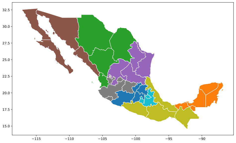
mexico.plot(column="maxp_new", categorical=True, figsize=(12,8), ec="w");
Locate
from spopt.locate import MCLP
from spopt.locate.util import simulated_geo_points
import numpy, geopandas, pulp, spaghetti

solver = pulp.PULP_CBC_CMD(msg=False, warmStart=True)
lattice = spaghetti.regular_lattice((0, 0, 10, 10), 9, exterior=True)
ntw = spaghetti.Network(in_data=lattice)
street = spaghetti.element_as_gdf(ntw, arcs=True)
street_buffered = geopandas.GeoDataFrame(
    geopandas.GeoSeries(street["geometry"].buffer(0.5).unary_union),
    crs=street.crs,
    columns=["geometry"],
)
client_points = simulated_geo_points(street_buffered, needed=100, seed=5)
ntw.snapobservations(client_points, "clients", attribute=True)
clients_snapped = spaghetti.element_as_gdf(
    ntw, pp_name="clients", snapped=True
)
facility_points = simulated_geo_points(street_buffered, needed=10, seed=6)
ntw.snapobservations(facility_points, "facilities", attribute=True)
facilities_snapped = spaghetti.element_as_gdf(
    ntw, pp_name="facilities", snapped=True
)
cost_matrix = ntw.allneighbordistances(
    sourcepattern=ntw.pointpatterns["clients"],
    destpattern=ntw.pointpatterns["facilities"],
)
numpy.random.seed(0)
ai = numpy.random.randint(1, 12, 100)
mclp_from_cost_matrix = MCLP.from_cost_matrix(cost_matrix, ai, 4, p_facilities=4)
mclp_from_cost_matrix = mclp_from_cost_matrix.solve(solver)
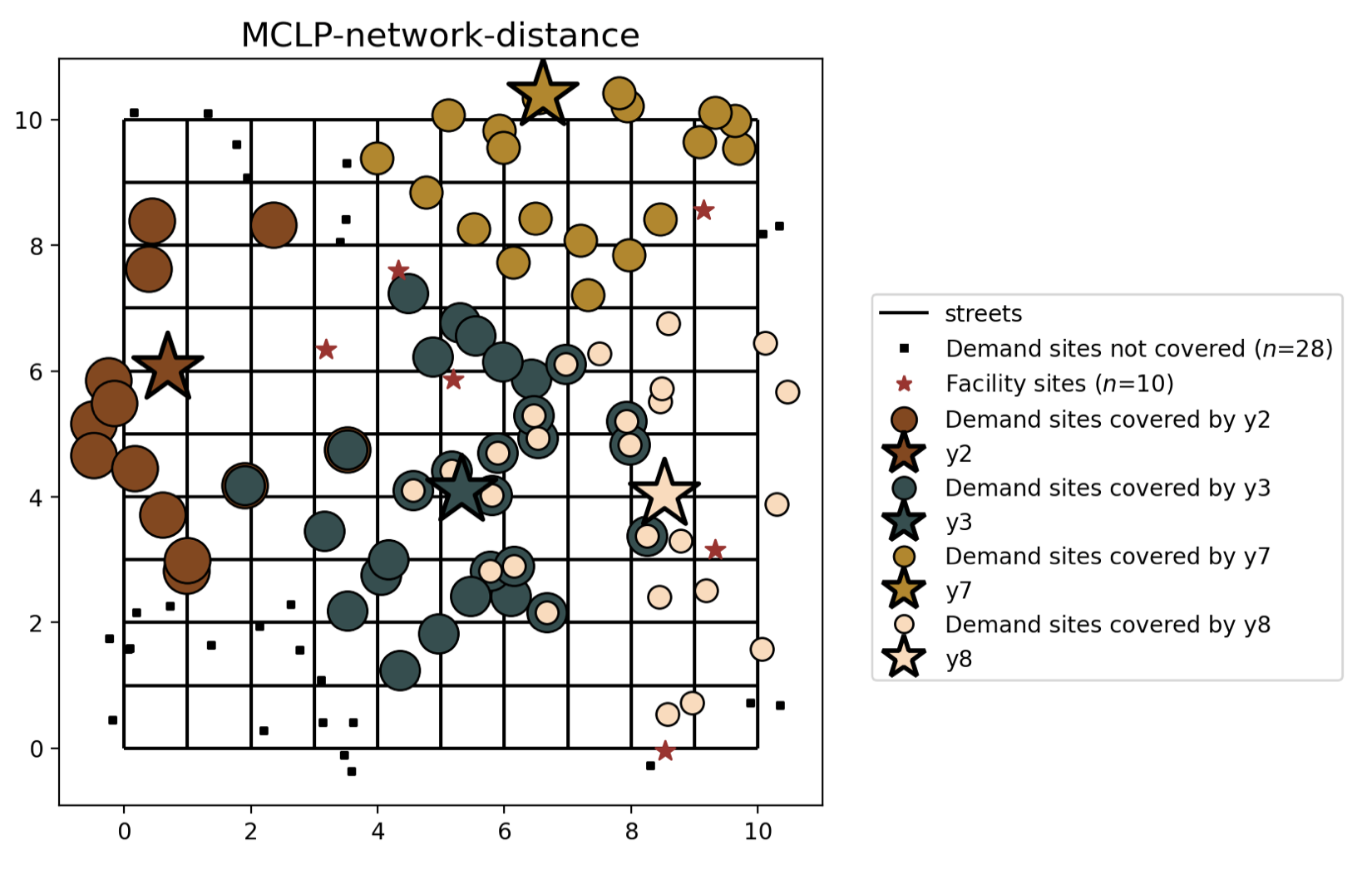
see notebook for plotting code
Examples
More examples can be found in the Tutorials section of the documentation.
All examples can be run interactively by launching this repository as a  .
.
Requirements
Installation
spopt is available on the Python Package Index. Therefore, you can either install directly with pip from the command line:
$ pip install -U spopt
or download the source distribution (.tar.gz) and decompress it to your selected destination. Open a command shell and navigate to the decompressed folder. Type:
$ pip install .
You may also install the latest stable spopt via conda-forge channel by running:
$ conda install --channel conda-forge spopt
Related packages
- Region
- Locate
Contribute
PySAL-spopt is under active development and contributors are welcome.
If you have any suggestions, feature requests, or bug reports, please open new issues on GitHub. To submit patches, please review PySAL's documentation for developers, the PySAL development guidelines, the spopt contributing guidelines before opening a pull request. Once your changes get merged, you’ll automatically be added to the Contributors List.
Support
If you are having trouble, please create an issue, start a discussion, or talk to us in PySAL's Discord channel.
Code of Conduct
As a PySAL-federated project, spopt follows the Code of Conduct under the PySAL governance model.
License
The project is licensed under the BSD 3-Clause license.
Citation
If you use PySAL-spopt in a scientific publication, we would appreciate using the following citations:
@misc{spopt2021,
    author    = {Feng, Xin, and Gaboardi, James D. and Knaap, Elijah and
                Rey, Sergio J. and Wei, Ran},
    month     = {jan},
    year      = {2021},
    title     = {pysal/spopt},
    url       = {https://github.com/pysal/spopt},
    doi       = {10.5281/zenodo.4444156},
    keywords  = {python,regionalization,spatial-optimization,location-modeling}
}

@article{spopt2022,
    author    = {Feng, Xin and Barcelos, Germano and Gaboardi, James D. and
                Knaap, Elijah and Wei, Ran and Wolf, Levi J. and
                Zhao, Qunshan and Rey, Sergio J.},
    year      = {2022},
    title     = {spopt: a python package for solving spatial optimization problems in PySAL},
    journal   = {Journal of Open Source Software},
    publisher = {The Open Journal},
    volume    = {7},
    number    = {74},
    pages     = {3330},
    url       = {https://doi.org/10.21105/joss.03330},
    doi       = {10.21105/joss.03330},
}
Funding
This project is/was partially funded through:
 National Science Foundation Award #1831615: RIDIR: Scalable Geospatial Analytics for Social Science Research
Contributors



Similar repos


Languages
Python
100.0%
README
spopt: Spatial Optimization
Regionalization, facility location, and transportation-oriented modeling
Spopt is an open-source Python library for solving optimization problems with spatial data. Originating from the region module in PySAL (Python Spatial Analysis Library), it is under active development for the inclusion of newly proposed models and methods for regionalization, facility location, and transportation-oriented solutions.
Regionalization
import spopt, libpysal, geopandas, numpy
mexico = geopandas.read_file(libpysal.examples.get_path("mexicojoin.shp"))
mexico["count"] = 1
attrs = [f"PCGDP{year}" for year in range(1950, 2010, 10)]
w = libpysal.weights.Queen.from_dataframe(mexico)
mexico["count"], threshold_name, threshold, top_n = 1, "count", 4, 2
numpy.random.seed(123456)
model = spopt.region.MaxPHeuristic(mexico, w, attrs, threshold_name, threshold, top_n)
model.solve()
mexico["maxp_new"] = model.labels_
mexico.plot(column="maxp_new", categorical=True, figsize=(12,8), ec="w");
Locate
from spopt.locate import MCLP
from spopt.locate.util import simulated_geo_points
import numpy, geopandas, pulp, spaghetti

solver = pulp.PULP_CBC_CMD(msg=False, warmStart=True)
lattice = spaghetti.regular_lattice((0, 0, 10, 10), 9, exterior=True)
ntw = spaghetti.Network(in_data=lattice)
street = spaghetti.element_as_gdf(ntw, arcs=True)
street_buffered = geopandas.GeoDataFrame(
    geopandas.GeoSeries(street["geometry"].buffer(0.5).unary_union),
    crs=street.crs,
    columns=["geometry"],
)
client_points = simulated_geo_points(street_buffered, needed=100, seed=5)
ntw.snapobservations(client_points, "clients", attribute=True)
clients_snapped = spaghetti.element_as_gdf(
    ntw, pp_name="clients", snapped=True
)
facility_points = simulated_geo_points(street_buffered, needed=10, seed=6)
ntw.snapobservations(facility_points, "facilities", attribute=True)
facilities_snapped = spaghetti.element_as_gdf(
    ntw, pp_name="facilities", snapped=True
)
cost_matrix = ntw.allneighbordistances(
    sourcepattern=ntw.pointpatterns["clients"],
    destpattern=ntw.pointpatterns["facilities"],
)
numpy.random.seed(0)
ai = numpy.random.randint(1, 12, 100)
mclp_from_cost_matrix = MCLP.from_cost_matrix(cost_matrix, ai, 4, p_facilities=4)
mclp_from_cost_matrix = mclp_from_cost_matrix.solve(solver)
see notebook for plotting code
Examples
More examples can be found in the Tutorials section of the documentation.
All examples can be run interactively by launching this repository as a .
Requirements
Installation
spopt is available on the Python Package Index. Therefore, you can either install directly with pip from the command line:
$ pip install -U spopt
or download the source distribution (.tar.gz) and decompress it to your selected destination. Open a command shell and navigate to the decompressed folder. Type:
$ pip install .
You may also install the latest stable spopt via conda-forge channel by running:
$ conda install --channel conda-forge spopt
Related packages
- Region
- Locate
Contribute
PySAL-spopt is under active development and contributors are welcome.
If you have any suggestions, feature requests, or bug reports, please open new issues on GitHub. To submit patches, please review PySAL's documentation for developers, the PySAL development guidelines, the spopt contributing guidelines before opening a pull request. Once your changes get merged, you’ll automatically be added to the Contributors List.
Support
If you are having trouble, please create an issue, start a discussion, or talk to us in PySAL's Discord channel.
Code of Conduct
As a PySAL-federated project, spopt follows the Code of Conduct under the PySAL governance model.
License
The project is licensed under the BSD 3-Clause license.
Citation
If you use PySAL-spopt in a scientific publication, we would appreciate using the following citations:
@misc{spopt2021,
    author    = {Feng, Xin, and Gaboardi, James D. and Knaap, Elijah and
                Rey, Sergio J. and Wei, Ran},
    month     = {jan},
    year      = {2021},
    title     = {pysal/spopt},
    url       = {https://github.com/pysal/spopt},
    doi       = {10.5281/zenodo.4444156},
    keywords  = {python,regionalization,spatial-optimization,location-modeling}
}

@article{spopt2022,
    author    = {Feng, Xin and Barcelos, Germano and Gaboardi, James D. and
                Knaap, Elijah and Wei, Ran and Wolf, Levi J. and
                Zhao, Qunshan and Rey, Sergio J.},
    year      = {2022},
    title     = {spopt: a python package for solving spatial optimization problems in PySAL},
    journal   = {Journal of Open Source Software},
    publisher = {The Open Journal},
    volume    = {7},
    number    = {74},
    pages     = {3330},
    url       = {https://doi.org/10.21105/joss.03330},
    doi       = {10.21105/joss.03330},
}
Funding
This project is/was partially funded through:
National Science Foundation Award #1831615: RIDIR: Scalable Geospatial Analytics for Social Science Research
Similar repos
Contributors
Languages
Python
100.0%