
A PyTorch implementation of "GeoSynth: Contextually-Aware High-Resolution Satellite Image Synthesis"
Python
118
13 commits
updated Nov 29, 2024
README
GeoSynth: Contextually-Aware High-Resolution Satellite Image Synthesis



This repository is the official implementation of GeoSynth [CVPRW, EarthVision, 2024]. GeoSynth is a suite of models for synthesizing satellite images with global style and image-driven layout control.
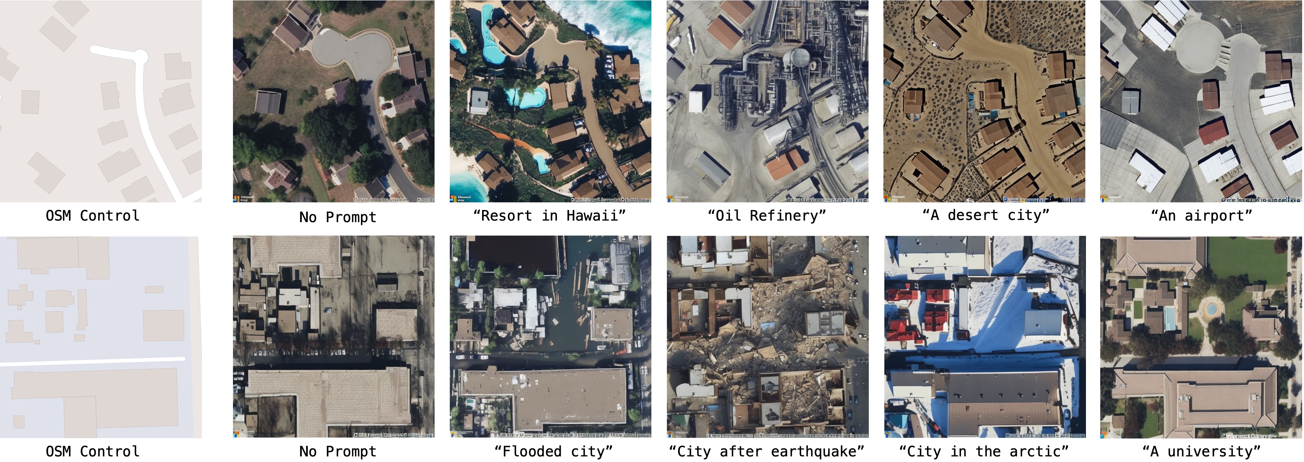
Models available in 🤗 HuggingFace diffusers:
GeoSynth:

GeoSynth-OSM:
GeoSynth-SAM:
GeoSynth-Canny:
All model ckpt files available here - Model Zoo
⏭️ Next
- Update Gradio demo
- Release Location-Aware GeoSynth Models to 🤗 HuggingFace
- Release PyTorch
ckptfiles for all models - Release GeoSynth Models to 🤗 HuggingFace
🌏 Inference
Example inference using 🤗 HuggingFace pipeline:
from diffusers import StableDiffusionControlNetPipeline, ControlNetModel
import torch
from PIL import Image

img = Image.open("osm_tile_18_42048_101323.jpeg")

controlnet = ControlNetModel.from_pretrained("MVRL/GeoSynth-OSM")

pipe = StableDiffusionControlNetPipeline.from_pretrained("stabilityai/stable-diffusion-2-1-base", controlnet=controlnet)
pipe = pipe.to("cuda:0")

# generate image
generator = torch.manual_seed(10345340)
image = pipe(
    "Satellite image features a city neighborhood",
    generator=generator,
    image=img,
).images[0]

image.save("generated_city.jpg")
📍 Geo-Awareness
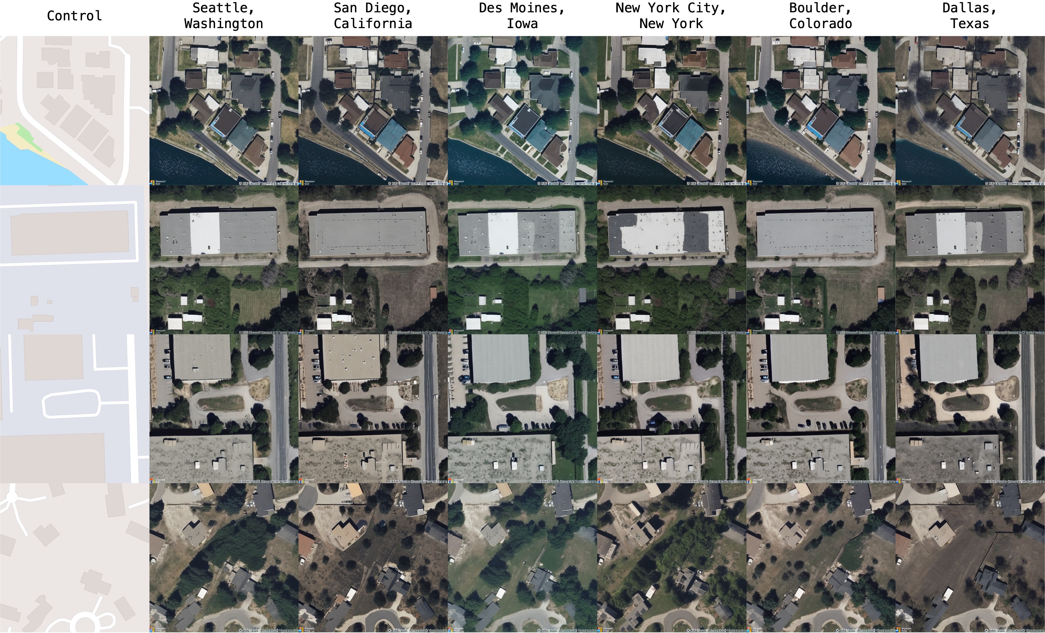
Our model is able to synthesize based on high-level geography of a region:
🧑💻 Setup and Training
Style for OSM imagery is created using MapBox. The style file can be downloaded from here. The dataset can be downloaded from here. Look at train.md for details on setting up the environment and training models on your own data.
🐨 Model Zoo
Download GeoSynth models from the given links below:
📑 Citation
@inproceedings{sastry2024geosynth,
  title={GeoSynth: Contextually-Aware High-Resolution Satellite Image Synthesis},
  author={Sastry, Srikumar and Khanal, Subash and Dhakal, Aayush and Jacobs, Nathan},
  booktitle={IEEE/ISPRS Workshop: Large Scale Computer Vision for Remote Sensing (EARTHVISION),
  year={2024}
}
🔍 Additional Links
Check out our lab website for other interesting works on geospatial understanding and mapping:
Contributors

13 commits
Similar repos



Languages
Python
99.9%
A PyTorch implementation of "GeoSynth: Contextually-Aware High-Resolution Satellite Image Synthesis"
Python
118
13 commits
updated Nov 29, 2024
README
GeoSynth: Contextually-Aware High-Resolution Satellite Image Synthesis
This repository is the official implementation of GeoSynth [CVPRW, EarthVision, 2024]. GeoSynth is a suite of models for synthesizing satellite images with global style and image-driven layout control.
Models available in 🤗 HuggingFace diffusers:
GeoSynth:
GeoSynth-OSM:
GeoSynth-SAM:
GeoSynth-Canny:
All model ckpt files available here - Model Zoo
⏭️ Next
- Update Gradio demo
- Release Location-Aware GeoSynth Models to 🤗 HuggingFace
- Release PyTorch
ckptfiles for all models - Release GeoSynth Models to 🤗 HuggingFace
🌏 Inference
Example inference using 🤗 HuggingFace pipeline:
from diffusers import StableDiffusionControlNetPipeline, ControlNetModel
import torch
from PIL import Image

img = Image.open("osm_tile_18_42048_101323.jpeg")

controlnet = ControlNetModel.from_pretrained("MVRL/GeoSynth-OSM")

pipe = StableDiffusionControlNetPipeline.from_pretrained("stabilityai/stable-diffusion-2-1-base", controlnet=controlnet)
pipe = pipe.to("cuda:0")

# generate image
generator = torch.manual_seed(10345340)
image = pipe(
    "Satellite image features a city neighborhood",
    generator=generator,
    image=img,
).images[0]

image.save("generated_city.jpg")
📍 Geo-Awareness
Our model is able to synthesize based on high-level geography of a region:
🧑💻 Setup and Training
Style for OSM imagery is created using MapBox. The style file can be downloaded from here. The dataset can be downloaded from here. Look at train.md for details on setting up the environment and training models on your own data.
🐨 Model Zoo
Download GeoSynth models from the given links below:
📑 Citation
@inproceedings{sastry2024geosynth,
  title={GeoSynth: Contextually-Aware High-Resolution Satellite Image Synthesis},
  author={Sastry, Srikumar and Khanal, Subash and Dhakal, Aayush and Jacobs, Nathan},
  booktitle={IEEE/ISPRS Workshop: Large Scale Computer Vision for Remote Sensing (EARTHVISION),
  year={2024}
}
🔍 Additional Links
Check out our lab website for other interesting works on geospatial understanding and mapping:
Similar repos
Contributors
13 commits
Languages
Python
99.9%