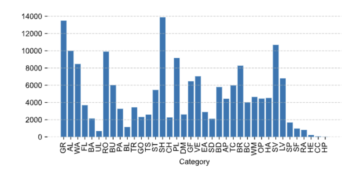
EarthSynth-180K is a multi-source remote-sensing dataset for mask-conditioned image synthesis and semantic understanding. It was introduced in EarthSynth: Generating Informative Earth Observation with Diffusion Models.
The counts below were read directly from the hosted Train archive and the locally audited Validation split on October 9, 2026. They replace earlier provisional counts.
| Split | Paired images/masks | Hosted annotations | Format |
|---|---|---|---|
| Train | 185,365 | Semantic masks | PNG pairs in a split ZIP |
| Validation | 6,836 | Semantic masks | PNG pairs in a split ZIP |
The currently hosted archives do not contain JSONL prompt files or the single-category augmented split. Text prompts can be derived from the class IDs, but derived prompts are not included in this release.
Each archive contains matching relative filenames under:
train/images/*.png
train/masks/*.png
val/images/*.png
val/masks/*.png
Install the Hugging Face CLI and download a snapshot:
hf download jaychempan/EarthSynth-180K --repo-type dataset --local-dir EarthSynth-180K
Reassemble each archive from its byte-contiguous parts:
cat EarthSynth-180K/train/train.zip_part_* > train.zip
unzip train.zip

cat EarthSynth-180K/val/val.zip_part_* > val.zip
unzip val.zip
The Validation split was checked exhaustively before upload:
LD_2832.png and LD_3438.png.Full counts, class statistics, file sizes, and SHA-256 checksums are in val/val_audit.json.
Validation archive SHA-256 after concatenating the parts:
d56067e9a4b2eddfe07ec05a1abcfbc47d68913fd53621a396b1da325b2994ec val.zip
Class IDs use the following mapping:
0 background; 1 bare land; 2 grass; 3 pavement; 4 road; 5 tree;
6 water; 7 agriculture land; 8 building; 9 forest land; 10 barren land;
11 urban land; 12 large vehicle; 13 swimming pool; 14 helicopter;
15 bridge; 16 plane; 17 ship; 18 soccer ball field; 19 basketball court;
20 ground track field; 21 small vehicle; 22 baseball diamond; 23 tennis court;
24 roundabout; 25 storage tank; 26 harbor; 27 container crane; 28 airport;
29 helipad; 30 chimney; 31 expressway service area;
32 expressway toll station; 33 dam; 34 golf field; 35 overpass; 36 stadium;
37 train station; 38 vehicle; 39 windmill; 40 A220; 41 A321; 42 A330;
43 A350; 44 ARJ21; 45 Boeing737; 46 Boeing747; 47 Boeing777;
48 Boeing787; 49 bus; 50 C919; 51 cargo truck; 52 dry cargo ship;
53 dump truck; 54 engineering ship; 55 excavator; 56 fishing boat;
57 intersection; 58 liquid cargo ship; 59 motorboat; 60 passenger ship;
61 tractor; 62 trailer; 63 truck tractor; 64 tugboat; 65 van; 66 warship
MIT License. Users should also review the terms of the source datasets listed above.
EarthSynth-180K is a multi-source remote-sensing dataset for mask-conditioned image synthesis and semantic understanding. It was introduced in EarthSynth: Generating Informative Earth Observation with Diffusion Models.
The counts below were read directly from the hosted Train archive and the locally audited Validation split on October 9, 2026. They replace earlier provisional counts.
| Split | Paired images/masks | Hosted annotations | Format |
|---|---|---|---|
| Train | 185,365 | Semantic masks | PNG pairs in a split ZIP |
| Validation | 6,836 | Semantic masks | PNG pairs in a split ZIP |
The currently hosted archives do not contain JSONL prompt files or the single-category augmented split. Text prompts can be derived from the class IDs, but derived prompts are not included in this release.
Each archive contains matching relative filenames under:
train/images/*.png
train/masks/*.png
val/images/*.png
val/masks/*.png
Install the Hugging Face CLI and download a snapshot:
hf download jaychempan/EarthSynth-180K --repo-type dataset --local-dir EarthSynth-180K
Reassemble each archive from its byte-contiguous parts:
cat EarthSynth-180K/train/train.zip_part_* > train.zip
unzip train.zip

cat EarthSynth-180K/val/val.zip_part_* > val.zip
unzip val.zip
The Validation split was checked exhaustively before upload:
LD_2832.png and LD_3438.png.Full counts, class statistics, file sizes, and SHA-256 checksums are in val/val_audit.json.
Validation archive SHA-256 after concatenating the parts:
d56067e9a4b2eddfe07ec05a1abcfbc47d68913fd53621a396b1da325b2994ec val.zip
Class IDs use the following mapping:
0 background; 1 bare land; 2 grass; 3 pavement; 4 road; 5 tree;
6 water; 7 agriculture land; 8 building; 9 forest land; 10 barren land;
11 urban land; 12 large vehicle; 13 swimming pool; 14 helicopter;
15 bridge; 16 plane; 17 ship; 18 soccer ball field; 19 basketball court;
20 ground track field; 21 small vehicle; 22 baseball diamond; 23 tennis court;
24 roundabout; 25 storage tank; 26 harbor; 27 container crane; 28 airport;
29 helipad; 30 chimney; 31 expressway service area;
32 expressway toll station; 33 dam; 34 golf field; 35 overpass; 36 stadium;
37 train station; 38 vehicle; 39 windmill; 40 A220; 41 A321; 42 A330;
43 A350; 44 ARJ21; 45 Boeing737; 46 Boeing747; 47 Boeing777;
48 Boeing787; 49 bus; 50 C919; 51 cargo truck; 52 dry cargo ship;
53 dump truck; 54 engineering ship; 55 excavator; 56 fishing boat;
57 intersection; 58 liquid cargo ship; 59 motorboat; 60 passenger ship;
61 tractor; 62 trailer; 63 truck tractor; 64 tugboat; 65 van; 66 warship
MIT License. Users should also review the terms of the source datasets listed above.