Contains a global coverage of Sentinel-2 (Level 2A) patches, each of size 1,068 x 1,068 pixels.
| Source | Sensing Type | Number of Patches | Patch Size | Total Pixels |
|---|---|---|---|---|
| Sentinel-2 Level-2A | Optical Multispectral | 2,245,886 | 1,068 x 1,068 (10 m) | > 2.564 Trillion |
| Column | Details | Resolution |
|---|---|---|
| B01 | Coastal aerosol, 442.7 nm (S2A), 442.3 nm (S2B) | 60m |
| B02 | Blue, 492.4 nm (S2A), 492.1 nm (S2B) | 10m |
| B03 | Green, 559.8 nm (S2A), 559.0 nm (S2B) | 10m |
| B04 | Red, 664.6 nm (S2A), 665.0 nm (S2B) | 10m |
| B05 | Vegetation red edge, 704.1 nm (S2A), 703.8 nm (S2B) | 20m |
| B06 | Vegetation red edge, 740.5 nm (S2A), 739.1 nm (S2B) | 20m |
| B07 | Vegetation red edge, 782.8 nm (S2A), 779.7 nm (S2B) | 20m |
| B08 | NIR, 832.8 nm (S2A), 833.0 nm (S2B) | 10m |
| B8A | Narrow NIR, 864.7 nm (S2A), 864.0 nm (S2B) | 20m |
| B09 | Water vapour, 945.1 nm (S2A), 943.2 nm (S2B) | 60m |
| B11 | SWIR, 1613.7 nm (S2A), 1610.4 nm (S2B) | 20m |
| B12 | SWIR, 2202.4 nm (S2A), 2185.7 nm (S2B) | 20m |
| cloud_mask | Cloud Mask produced by SEnSeI | 10m |
| thumbnail | RGB composite [B04, B03, B02] saved as png | 10m |
This is a global monotemporal dataset. Nearly every piece of Earth captured by Sentinel-2 is contained at least once in this dataset (and only once, excluding some marginal overlaps).
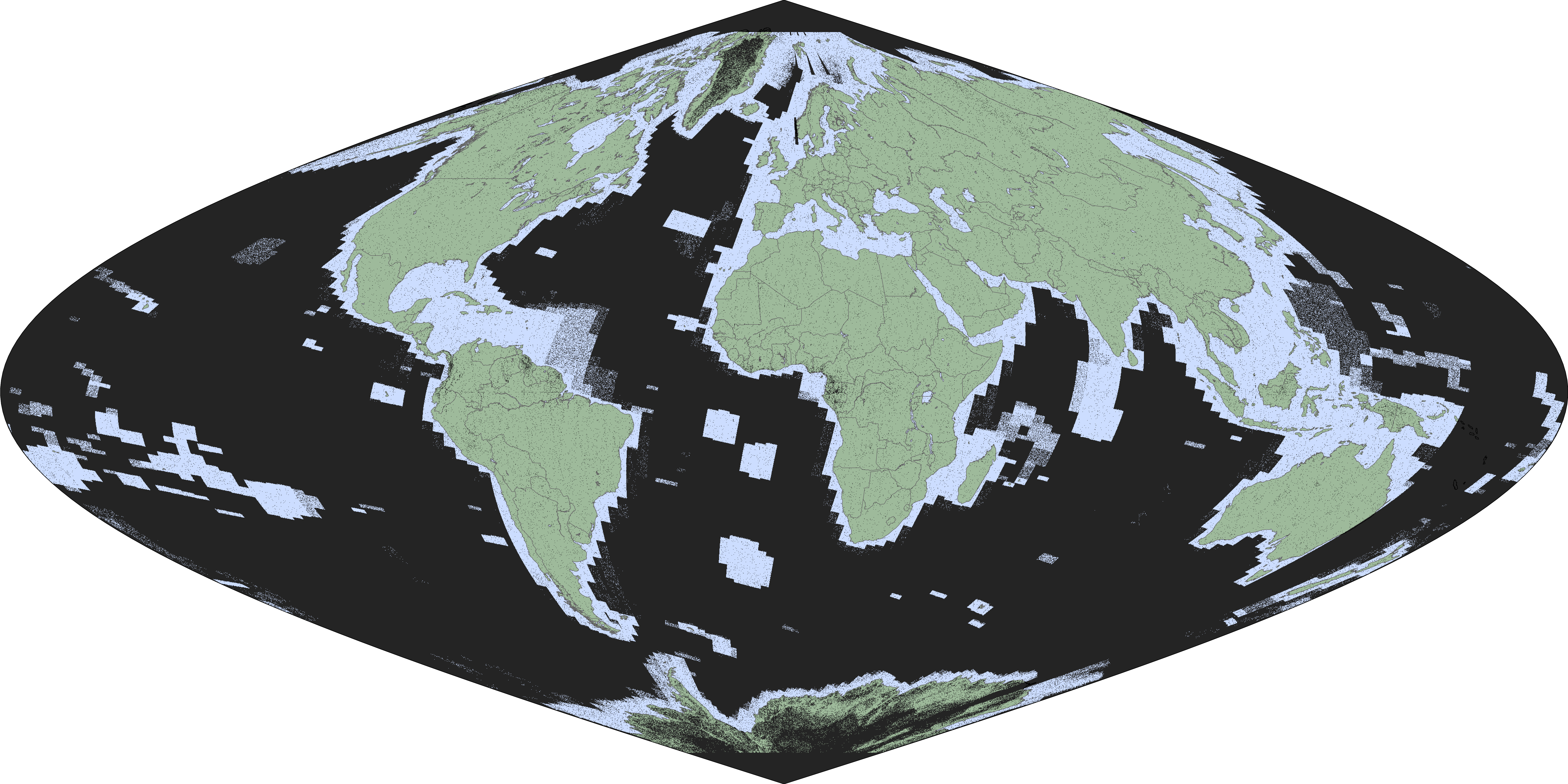
The following figure demonstrates the spatial coverage (only black pixels are absent):
Interface scripts are available at https://github.com/ESA-PhiLab/Major-TOM
Here's a sneak peek with a thumbnail image:
from fsspec.parquet import open_parquet_file
import pyarrow.parquet as pq
from io import BytesIO
from PIL import Image

PARQUET_FILE = 'part_03900' # parquet number
ROW_INDEX = 42 # row number (about 500 per parquet)

url = "https://huggingface.co/datasets/Major-TOM/Core-S2L2A/resolve/main/images/{}.parquet".format(PARQUET_FILE)
with open_parquet_file(url,columns = ["thumbnail"]) as f:
    with pq.ParquetFile(f) as pf:
        first_row_group = pf.read_row_group(ROW_INDEX, columns=['thumbnail'])

stream = BytesIO(first_row_group['thumbnail'][0].as_py())
image = Image.open(stream)
@inproceedings{Major_TOM,
  title={Major TOM: Expandable Datasets for Earth Observation},
  author={Alistair Francis and Mikolaj Czerkawski},
  year={2024},
  booktitle={IGARSS 2024 - 2024 IEEE International Geoscience and Remote Sensing Symposium},
  eprint={2402.12095},
  archivePrefix={arXiv},
  primaryClass={cs.CV}
}
Powered by Φ-lab, European Space Agency (ESA) 🛰️
Contains a global coverage of Sentinel-2 (Level 2A) patches, each of size 1,068 x 1,068 pixels.
| Source | Sensing Type | Number of Patches | Patch Size | Total Pixels |
|---|---|---|---|---|
| Sentinel-2 Level-2A | Optical Multispectral | 2,245,886 | 1,068 x 1,068 (10 m) | > 2.564 Trillion |
| Column | Details | Resolution |
|---|---|---|
| B01 | Coastal aerosol, 442.7 nm (S2A), 442.3 nm (S2B) | 60m |
| B02 | Blue, 492.4 nm (S2A), 492.1 nm (S2B) | 10m |
| B03 | Green, 559.8 nm (S2A), 559.0 nm (S2B) | 10m |
| B04 | Red, 664.6 nm (S2A), 665.0 nm (S2B) | 10m |
| B05 | Vegetation red edge, 704.1 nm (S2A), 703.8 nm (S2B) | 20m |
| B06 | Vegetation red edge, 740.5 nm (S2A), 739.1 nm (S2B) | 20m |
| B07 | Vegetation red edge, 782.8 nm (S2A), 779.7 nm (S2B) | 20m |
| B08 | NIR, 832.8 nm (S2A), 833.0 nm (S2B) | 10m |
| B8A | Narrow NIR, 864.7 nm (S2A), 864.0 nm (S2B) | 20m |
| B09 | Water vapour, 945.1 nm (S2A), 943.2 nm (S2B) | 60m |
| B11 | SWIR, 1613.7 nm (S2A), 1610.4 nm (S2B) | 20m |
| B12 | SWIR, 2202.4 nm (S2A), 2185.7 nm (S2B) | 20m |
| cloud_mask | Cloud Mask produced by SEnSeI | 10m |
| thumbnail | RGB composite [B04, B03, B02] saved as png | 10m |
This is a global monotemporal dataset. Nearly every piece of Earth captured by Sentinel-2 is contained at least once in this dataset (and only once, excluding some marginal overlaps).
The following figure demonstrates the spatial coverage (only black pixels are absent):
Interface scripts are available at https://github.com/ESA-PhiLab/Major-TOM
Here's a sneak peek with a thumbnail image:
from fsspec.parquet import open_parquet_file
import pyarrow.parquet as pq
from io import BytesIO
from PIL import Image

PARQUET_FILE = 'part_03900' # parquet number
ROW_INDEX = 42 # row number (about 500 per parquet)

url = "https://huggingface.co/datasets/Major-TOM/Core-S2L2A/resolve/main/images/{}.parquet".format(PARQUET_FILE)
with open_parquet_file(url,columns = ["thumbnail"]) as f:
    with pq.ParquetFile(f) as pf:
        first_row_group = pf.read_row_group(ROW_INDEX, columns=['thumbnail'])

stream = BytesIO(first_row_group['thumbnail'][0].as_py())
image = Image.open(stream)
@inproceedings{Major_TOM,
  title={Major TOM: Expandable Datasets for Earth Observation},
  author={Alistair Francis and Mikolaj Czerkawski},
  year={2024},
  booktitle={IGARSS 2024 - 2024 IEEE International Geoscience and Remote Sensing Symposium},
  eprint={2402.12095},
  archivePrefix={arXiv},
  primaryClass={cs.CV}
}
Powered by Φ-lab, European Space Agency (ESA) 🛰️