
🛰️ GeoAI.js is a javascript library for use with transformers.js to perform GeoAI on the frontend
173
stars
389
commits
TypeScript
primary language
Aug 11, 2026
updated
README
GeoAI.js
Geospatial AI that runs in the browser.
Detect buildings, vehicles, ships, solar panels, and more — on satellite & aerial imagery — without a GPU backend.





Live demos → · Docs → · Agent skill →
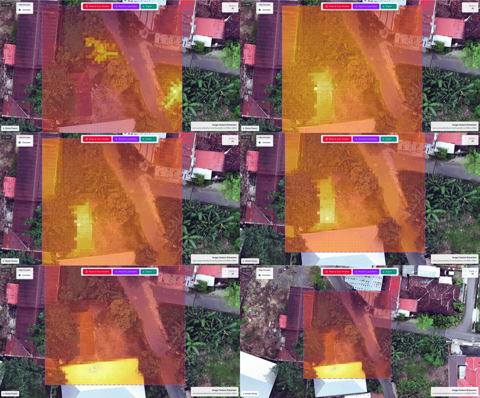
DINOv3 image feature extraction in the browser — try it at docs.geobase.app/geoai-live
Why GeoAI.js?
| Client-side | Models run in the browser (WebGPU / WASM) via Transformers.js + ONNX Runtime |
| Draw → detect | Pass a GeoJSON polygon; get detections back as GeoJSON |
| Your imagery | ESRI, Mapbox, Geobase COGs, TMS, WMS, OpenAerialMap, Google Map Tiles |
| Pipeline-ready | Chain tasks; run inference off the main thread with workers |
npm i geoai
# peers
npm i @huggingface/transformers onnxruntime-web
import { geoai } from "geoai";

const pipeline = await geoai.pipeline([{ task: "building-detection" }], {
  provider: "esri", // no API key
});

const result = await pipeline.inference({
  inputs: { polygon: myGeoJsonPolygon },
  mapSourceParams: { zoomLevel: 18 },
});
// result.detections → GeoJSON FeatureCollection
CDN:
<script src="https://unpkg.com/geoai@1.0.7/geoai.js"></script>
<!-- or -->
<script src="https://cdn.jsdelivr.net/npm/geoai@1.0.7/geoai.min.js"></script>
Use cases
GeoAI.js is built for product teams and researchers who need interactive geospatial AI — not batch jobs on a remote GPU cluster.
- Urban inventory — building footprints & boxes for planning, insurance, or change tracking
- Energy & infrastructure — solar panels, oil storage tanks, utility assets
- Transport & logistics — cars, trucks, ships in ports and yards
- Environment — land cover and wetland segmentation over AOIs
- Exploration — zero-shot detection and DINOv3 embeddings for similarity search
Draw an AOI on a map, run a model, store or style the GeoJSON — all in one frontend session.
Integrations
Persist detections, sync in real time, and serve results as vector tiles.
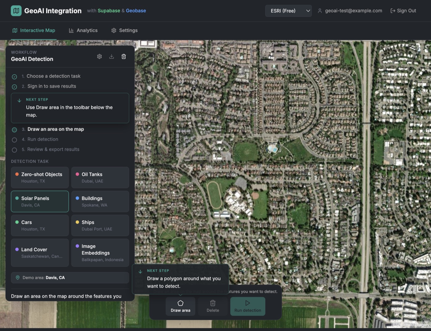
Full-stack demo: draw → detect → save to PostGIS (Supabase or Geobase) with live map layers
| Stack | What you get |
|---|---|
| Supabase | Auth, PostGIS storage, realtime subscriptions for detection history |
| Geobase | Same PostGIS path plus vector tileserver for thousands of styled detections |
| MapLibre / React | Interactive task demos (live); also 01-quickstart |
| deck.gl | GPU-friendly overlay workflows |
| Agent skill | Cursor / Claude / Codex integration via skills/geoai |
Quick links:
- Example app + guide:
examples/04-geoai-supabase-geobase-integration - Integration write-up:
INTEGRATION_GUIDE.md - Interactive tasks: docs.geobase.app/geoai-live
Map providers
Point the pipeline at the imagery you already use:
| Provider | Auth | Notes |
|---|---|---|
| ESRI | None | World Imagery — great default for demos |
| Mapbox | Token | Satellite styles |
| Geobase | Project + API key | Your COG / tileserver |
| TMS | Optional | Any {z}/{x}/{y} raster URL |
| WMS | Usually none | OGC GetMap (e.g. NRW orthophotos) |
| OpenAerialMap | None | HOT Imagery STAC + TiTiler |
| API key | Map Tiles API (session + XYZ); prefer a server proxy in browsers |
// Free public imagery
{ provider: "esri" }

// Community aerial (OAM)
{ provider: "oam" /* , itemId, mosaic: true */ }

// Your COG on Geobase
{
  provider: "geobase",
  projectRef: "...",
  apikey: "...",
  cogImagery: "https://path-to-your-cog.tif",
}

// Google Map Tiles (enable Map Tiles API; avoid HTTP-referrer–only keys)
{ provider: "google", apiKey: process.env.GOOGLE_MAPS_API_KEY }
Docs: Map providers
Supported tasks
Object detection · Building detection · Building footprint segmentation (ChangeStar) · Car · Ship · Solar panel · Oil storage tank · Oriented object detection · Land cover · Wetland · Mask generation · Zero-shot detection & segmentation · Image feature extraction (DINOv3)
Workers & React
Keep the UI smooth — run inference in a Web Worker. Patterns for vanilla JS and React live in the skill and docs (there is no separate geoai/react package export; use the worker + hook examples).
Quickstart clone
git init
git subtree add --prefix=examples/01-quickstart \
  https://github.com/decision-labs/geoai.js main --squash
cd examples/01-quickstart && npm install && npm run dev
Agents & LLMs
Teach coding agents how to integrate GeoAI.js:
npx skills add decision-labs/geoai.js --skill geoai -y
# or globally
npx skills add decision-labs/geoai.js --skill geoai -g -y
- Skill source:
skills/geoai - LLM docs index: llms.txt
- Full corpus: llms-full.txt (
pnpm docs:llms)
Talk
Bringing Earth Observation AI to the Browser with WebGPU — Big Data from Space 2025 (Decision Labs).

Links
- Docs — docs.geobase.app/geoai
- Live examples — docs.geobase.app/geoai-live
- npm — geoai
- Roadmap — _docs4devs/ROADMAP.md
- Discussions — GitHub Discussions
- Issues — GitHub Issues
Contributing
See CONTRIBUTING.md.
License
MIT — LICENSE.md
Contributors


Similar repos


Languages
TypeScript
70.3%
Jupyter Notebook
21.6%
Python
5.9%
Shell
1.4%
🛰️ GeoAI.js is a javascript library for use with transformers.js to perform GeoAI on the frontend
173
stars
389
commits
TypeScript
primary language
Aug 11, 2026
updated
README
GeoAI.js
Geospatial AI that runs in the browser.
Detect buildings, vehicles, ships, solar panels, and more — on satellite & aerial imagery — without a GPU backend.
Live demos → · Docs → · Agent skill →
DINOv3 image feature extraction in the browser — try it at docs.geobase.app/geoai-live
Why GeoAI.js?
| Client-side | Models run in the browser (WebGPU / WASM) via Transformers.js + ONNX Runtime |
| Draw → detect | Pass a GeoJSON polygon; get detections back as GeoJSON |
| Your imagery | ESRI, Mapbox, Geobase COGs, TMS, WMS, OpenAerialMap, Google Map Tiles |
| Pipeline-ready | Chain tasks; run inference off the main thread with workers |
npm i geoai
# peers
npm i @huggingface/transformers onnxruntime-web
import { geoai } from "geoai";

const pipeline = await geoai.pipeline([{ task: "building-detection" }], {
  provider: "esri", // no API key
});

const result = await pipeline.inference({
  inputs: { polygon: myGeoJsonPolygon },
  mapSourceParams: { zoomLevel: 18 },
});
// result.detections → GeoJSON FeatureCollection
CDN:
<script src="https://unpkg.com/geoai@1.0.7/geoai.js"></script>
<!-- or -->
<script src="https://cdn.jsdelivr.net/npm/geoai@1.0.7/geoai.min.js"></script>
Use cases
GeoAI.js is built for product teams and researchers who need interactive geospatial AI — not batch jobs on a remote GPU cluster.
- Urban inventory — building footprints & boxes for planning, insurance, or change tracking
- Energy & infrastructure — solar panels, oil storage tanks, utility assets
- Transport & logistics — cars, trucks, ships in ports and yards
- Environment — land cover and wetland segmentation over AOIs
- Exploration — zero-shot detection and DINOv3 embeddings for similarity search
Draw an AOI on a map, run a model, store or style the GeoJSON — all in one frontend session.
Integrations
Persist detections, sync in real time, and serve results as vector tiles.
Full-stack demo: draw → detect → save to PostGIS (Supabase or Geobase) with live map layers
| Stack | What you get |
|---|---|
| Supabase | Auth, PostGIS storage, realtime subscriptions for detection history |
| Geobase | Same PostGIS path plus vector tileserver for thousands of styled detections |
| MapLibre / React | Interactive task demos (live); also 01-quickstart |
| deck.gl | GPU-friendly overlay workflows |
| Agent skill | Cursor / Claude / Codex integration via skills/geoai |
Quick links:
- Example app + guide:
examples/04-geoai-supabase-geobase-integration - Integration write-up:
INTEGRATION_GUIDE.md - Interactive tasks: docs.geobase.app/geoai-live
Map providers
Point the pipeline at the imagery you already use:
| Provider | Auth | Notes |
|---|---|---|
| ESRI | None | World Imagery — great default for demos |
| Mapbox | Token | Satellite styles |
| Geobase | Project + API key | Your COG / tileserver |
| TMS | Optional | Any {z}/{x}/{y} raster URL |
| WMS | Usually none | OGC GetMap (e.g. NRW orthophotos) |
| OpenAerialMap | None | HOT Imagery STAC + TiTiler |
| API key | Map Tiles API (session + XYZ); prefer a server proxy in browsers |
// Free public imagery
{ provider: "esri" }

// Community aerial (OAM)
{ provider: "oam" /* , itemId, mosaic: true */ }

// Your COG on Geobase
{
  provider: "geobase",
  projectRef: "...",
  apikey: "...",
  cogImagery: "https://path-to-your-cog.tif",
}

// Google Map Tiles (enable Map Tiles API; avoid HTTP-referrer–only keys)
{ provider: "google", apiKey: process.env.GOOGLE_MAPS_API_KEY }
Docs: Map providers
Supported tasks
Object detection · Building detection · Building footprint segmentation (ChangeStar) · Car · Ship · Solar panel · Oil storage tank · Oriented object detection · Land cover · Wetland · Mask generation · Zero-shot detection & segmentation · Image feature extraction (DINOv3)
Workers & React
Keep the UI smooth — run inference in a Web Worker. Patterns for vanilla JS and React live in the skill and docs (there is no separate geoai/react package export; use the worker + hook examples).
Quickstart clone
git init
git subtree add --prefix=examples/01-quickstart \
  https://github.com/decision-labs/geoai.js main --squash
cd examples/01-quickstart && npm install && npm run dev
Agents & LLMs
Teach coding agents how to integrate GeoAI.js:
npx skills add decision-labs/geoai.js --skill geoai -y
# or globally
npx skills add decision-labs/geoai.js --skill geoai -g -y
- Skill source:
skills/geoai - LLM docs index: llms.txt
- Full corpus: llms-full.txt (
pnpm docs:llms)
Talk
Bringing Earth Observation AI to the Browser with WebGPU — Big Data from Space 2025 (Decision Labs).
Links
- Docs — docs.geobase.app/geoai
- Live examples — docs.geobase.app/geoai-live
- npm — geoai
- Roadmap — _docs4devs/ROADMAP.md
- Discussions — GitHub Discussions
- Issues — GitHub Issues
Contributing
See CONTRIBUTING.md.
License
MIT — LICENSE.md
Similar repos
Contributors
Languages
TypeScript
70.3%
Jupyter Notebook
21.6%
Python
5.9%
Shell
1.4%