
One line code to get any remote sensing foundation model embeddings for any place and any time
See the codeREADME
 rs-embed
One line code to get Any Remote Sensing Foundation Model (RSFM) embeddings for Any Place and Any Time







Get Start on I-GUIDE Today!
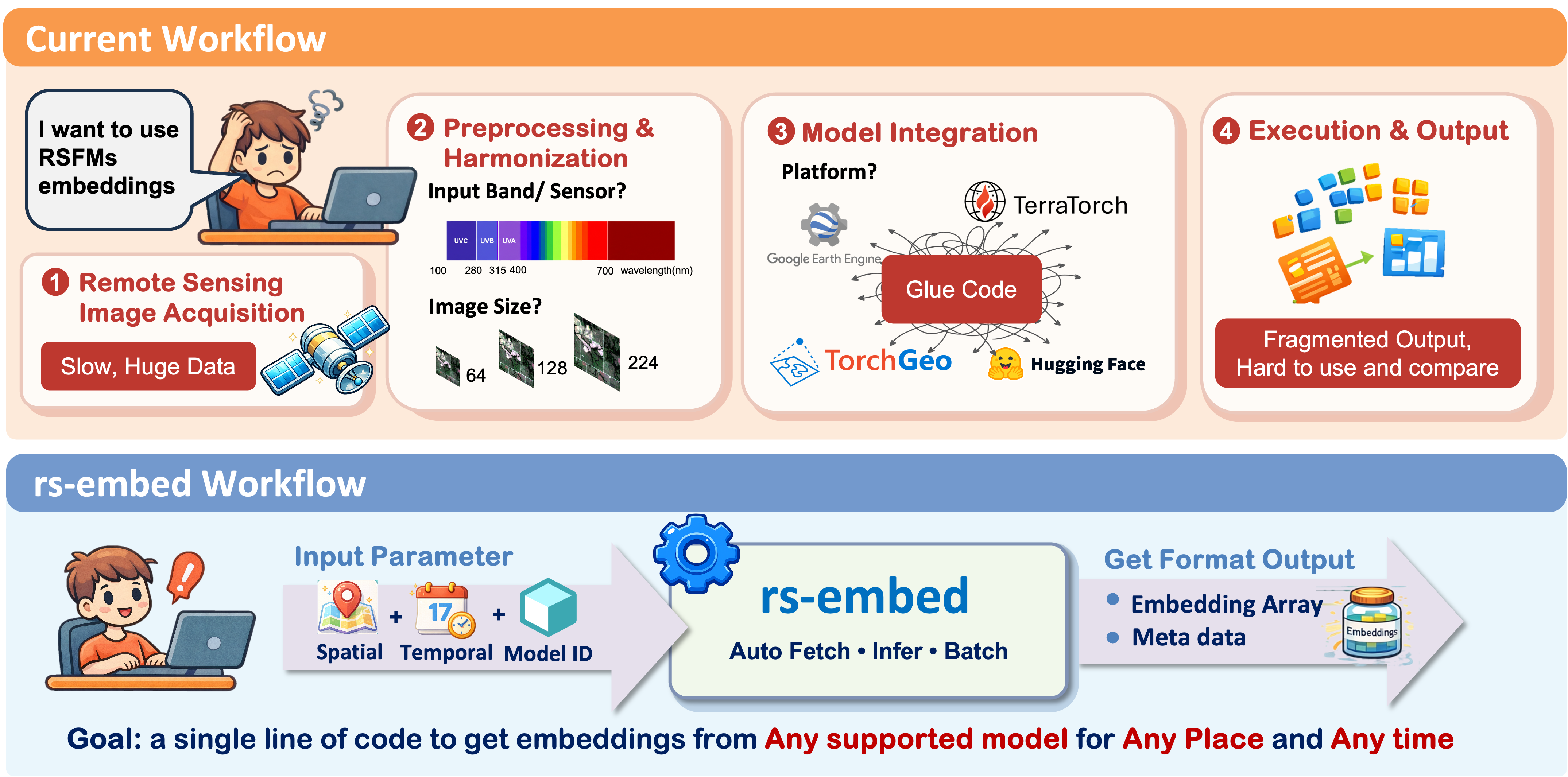
TL;DR
emb = get_embedding("prithvi", spatial=..., temporal=..., output=...)
Install
# base install (always use the latest version for best experience)
pip install --upgrade rs-embed

# add [terratorch] only if you use terramind
pip install --upgrade "rs-embed[terratorch]"
For local development:
git clone https://github.com/cybergis/rs-embed.git
cd rs-embed
pip install -e .  # use -e ".[terratorch]" if you need terramind
If this is your first time using Google Earth Engine, authenticate once:
earthengine authenticate
Quick Example
from rs_embed import PointBuffer, TemporalSpec, OutputSpec, get_embedding

spatial = PointBuffer(lon=121.5, lat=31.2, buffer_m=2048)
temporal = TemporalSpec.range(
    "2022-06-01",
    "2022-09-01",
)

emb = get_embedding(
    "prithvi",
    spatial=spatial,
    temporal=temporal,
    output=OutputSpec.pooled(),
)
Tip: Default settings are designed as a trade-off between compute cost and embedding quality. If you have sufficient compute resources, check Choosing Settings and individual model pages to get the best results.
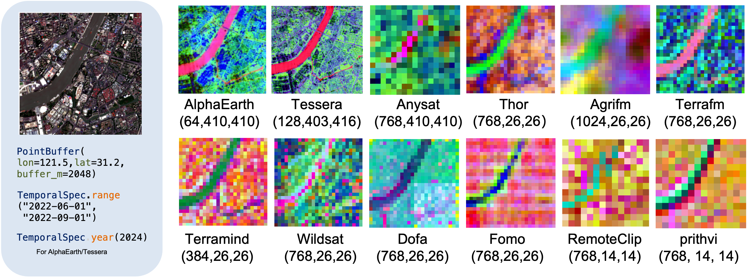
See the visualization helper and end-to-end notebook in the repository:
Bring Your Own Data
🆕 New: you can now compute embeddings from imagery you already have (your own patches, GeoTIFFs, training cubes), with no Google Earth Engine fetch and no provider auth.
Register the pixels once as UserData (raw provider values plus collection, band names, and optionally where/when they were acquired), then embed with just a model name:
from rs_embed import UserData, get_embedding_from_data, list_models_for_data

data = UserData(patch, collection="s2")  # patch: [12, H, W] Sentinel-2 L2A, raw DN
# or read pixels + CRS + transform straight from a GeoTIFF:
# data = UserData.from_raster("scene.tif", collection="s2")

list_models_for_data(data)                    # which models can use this data, and why not
emb = get_embedding_from_data("galileo", data)
Bands are matched to each model automatically (a 12-band cube serves RGB, 6-band, and 10-band models alike), and a model your data cannot satisfy is refused with the exact missing band instead of producing silently wrong embeddings. See the User-Provided Data guide and examples/bring_your_own_data.ipynb.
Main API
For new users, start with these primary APIs:
get_embedding(...): one ROI -> one embeddingget_embeddings_batch(...): many ROIs, same modelexport_batch(...): export datasets / experiments (single or multiple ROIs)inspect_provider_patch(...): inspect raw provider patches before inferenceget_embedding_from_data(...)/get_embeddings_batch_from_data(...): embed your own imagery (see Bring Your Own Data)
Supported Models
This is a convenience index with basic model info only (for quick scanning / links). For detailed I/O behavior and preprocessing notes, see Supported Models.
Precomputed Embeddings
| Model ID | Resolution | Time Coverage | Publication |
|---|---|---|---|
tessera | 10m | 2017-2025 | CVPR 2026 |
gse (Alpha Earth) | 10 m | 2017-2024 | arXiv 2025 |
copernicus | 0.25° | 2021 | ICCV 2025 |
On-the-fly Foundation Models
| Model ID | Primary Input | Resolution(Default) | Publication | Link |
|---|---|---|---|---|
olmoearth | S2 L2A 12-band / S1 VV-VH | 10m | CVPR 2026 | link |
agrifm | S2 time series (10-band) | 10m | RSE 2026 | link |
thor | S2 10-band | 10m | arXiv 2026 | link |
terrafm | S2 12-band / S1 VV-VH | 10m | ICLR 2026 | link |
terramind | S2 12-band | 10m | ICCV 2025 | link |
galileo | S2 time series (10-band) | 10m | ICML 2025 | link |
wildsat | S2 RGB | 10m | ICCV 2025 | link |
anysat | S2 time series (10-band) | 10m | CVPR 2025 | link |
fomo | S2 12-band | 10m | AAAI 2025 | link |
prithvi | S2 6-band | 30m | arXiv 2024 | link |
satvision | TOA 14-channel | 1000m | arXiv 2024 | link |
dofa | Multi-band + wavelengths | 10m | arXiv 2024 | link |
clay | S2 L2A 10-band (+ latlon/time/gsd/wavelengths) | 10m | model release v1.5, 2024 | link |
satmaepp | S2 RGB (modality=rgb, default) or S2 SR 10-band (modality=s2_10b) | 10m | CVPR 2024 | link |
remoteclip | S2 RGB | 10m | TGRS 2024 | link |
scalemae | S2 RGB (+ scale) | 10m | ICCV 2023 | link |
satmae | S2 RGB | 10m | NeurIPS 2022 | link |
Resolution here means the default provider/source fetch resolution used by the adapter, not the final resized tensor shape seen by the model.
Learn More
🪄 Get Started: Try rs-embed Now
🪀 Use case: Maize yield mapping Illinois
🗂️ Bring your own data: embed your own imagery
🧾 Release policy and versioning
Extending & Contributing
We welcome issues for new model integrations, extension ideas, bugs, and documentation gaps. If you have your own work, or a model or paper that you think would be valuable to include in rs-embed, please open an Issue and share the relevant links, context, and examples.
We also warmly welcome community contributions, including new model support, bug fixes, documentation improvements, and example notebooks. If you would like to contribute directly, please start with the extending guide and the contributing guide.
🎖 Acknowledgements
We would like to thank the following organizations and projects that make rs-embed possible: Google Earth Engine, TorchGeo, GeoTessera, TerraTorch, rshf, and the Copernicus-Embed.
This library also builds upon the incredible work of the Remote Sensing community!(Full list and citations available in our Documentation)
Citation
@article{ye2026modelplacetimeremote,
      title={Any Model, Any Place, Any Time: Get Remote Sensing Foundation Model Embeddings On Demand},
      author={Dingqi Ye and Daniel Kiv and Wei Hu and Jimeng Shi and Shaowen Wang},
      year={2026},
      eprint={2602.23678},
      archivePrefix={arXiv},
      primaryClass={cs.CV},
      url={https://arxiv.org/abs/2602.23678},
}
License
This project is released under the Apache-2.0
Contributors
Similar repos


Languages
Python
100.0%
One line code to get any remote sensing foundation model embeddings for any place and any time
See the codeREADME
rs-embed
One line code to get Any Remote Sensing Foundation Model (RSFM) embeddings for Any Place and Any Time
Get Start on I-GUIDE Today!
TL;DR
emb = get_embedding("prithvi", spatial=..., temporal=..., output=...)
Install
# base install (always use the latest version for best experience)
pip install --upgrade rs-embed

# add [terratorch] only if you use terramind
pip install --upgrade "rs-embed[terratorch]"
For local development:
git clone https://github.com/cybergis/rs-embed.git
cd rs-embed
pip install -e .  # use -e ".[terratorch]" if you need terramind
If this is your first time using Google Earth Engine, authenticate once:
earthengine authenticate
Quick Example
from rs_embed import PointBuffer, TemporalSpec, OutputSpec, get_embedding

spatial = PointBuffer(lon=121.5, lat=31.2, buffer_m=2048)
temporal = TemporalSpec.range(
    "2022-06-01",
    "2022-09-01",
)

emb = get_embedding(
    "prithvi",
    spatial=spatial,
    temporal=temporal,
    output=OutputSpec.pooled(),
)
Tip: Default settings are designed as a trade-off between compute cost and embedding quality. If you have sufficient compute resources, check Choosing Settings and individual model pages to get the best results.
See the visualization helper and end-to-end notebook in the repository:
Bring Your Own Data
🆕 New: you can now compute embeddings from imagery you already have (your own patches, GeoTIFFs, training cubes), with no Google Earth Engine fetch and no provider auth.
Register the pixels once as UserData (raw provider values plus collection, band names, and optionally where/when they were acquired), then embed with just a model name:
from rs_embed import UserData, get_embedding_from_data, list_models_for_data

data = UserData(patch, collection="s2")  # patch: [12, H, W] Sentinel-2 L2A, raw DN
# or read pixels + CRS + transform straight from a GeoTIFF:
# data = UserData.from_raster("scene.tif", collection="s2")

list_models_for_data(data)                    # which models can use this data, and why not
emb = get_embedding_from_data("galileo", data)
Bands are matched to each model automatically (a 12-band cube serves RGB, 6-band, and 10-band models alike), and a model your data cannot satisfy is refused with the exact missing band instead of producing silently wrong embeddings. See the User-Provided Data guide and examples/bring_your_own_data.ipynb.
Main API
For new users, start with these primary APIs:
get_embedding(...): one ROI -> one embeddingget_embeddings_batch(...): many ROIs, same modelexport_batch(...): export datasets / experiments (single or multiple ROIs)inspect_provider_patch(...): inspect raw provider patches before inferenceget_embedding_from_data(...)/get_embeddings_batch_from_data(...): embed your own imagery (see Bring Your Own Data)
Supported Models
This is a convenience index with basic model info only (for quick scanning / links). For detailed I/O behavior and preprocessing notes, see Supported Models.
Precomputed Embeddings
| Model ID | Resolution | Time Coverage | Publication |
|---|---|---|---|
tessera | 10m | 2017-2025 | CVPR 2026 |
gse (Alpha Earth) | 10 m | 2017-2024 | arXiv 2025 |
copernicus | 0.25° | 2021 | ICCV 2025 |
On-the-fly Foundation Models
| Model ID | Primary Input | Resolution(Default) | Publication | Link |
|---|---|---|---|---|
olmoearth | S2 L2A 12-band / S1 VV-VH | 10m | CVPR 2026 | link |
agrifm | S2 time series (10-band) | 10m | RSE 2026 | link |
thor | S2 10-band | 10m | arXiv 2026 | link |
terrafm | S2 12-band / S1 VV-VH | 10m | ICLR 2026 | link |
terramind | S2 12-band | 10m | ICCV 2025 | link |
galileo | S2 time series (10-band) | 10m | ICML 2025 | link |
wildsat | S2 RGB | 10m | ICCV 2025 | link |
anysat | S2 time series (10-band) | 10m | CVPR 2025 | link |
fomo | S2 12-band | 10m | AAAI 2025 | link |
prithvi | S2 6-band | 30m | arXiv 2024 | link |
satvision | TOA 14-channel | 1000m | arXiv 2024 | link |
dofa | Multi-band + wavelengths | 10m | arXiv 2024 | link |
clay | S2 L2A 10-band (+ latlon/time/gsd/wavelengths) | 10m | model release v1.5, 2024 | link |
satmaepp | S2 RGB (modality=rgb, default) or S2 SR 10-band (modality=s2_10b) | 10m | CVPR 2024 | link |
remoteclip | S2 RGB | 10m | TGRS 2024 | link |
scalemae | S2 RGB (+ scale) | 10m | ICCV 2023 | link |
satmae | S2 RGB | 10m | NeurIPS 2022 | link |
Resolution here means the default provider/source fetch resolution used by the adapter, not the final resized tensor shape seen by the model.
Learn More
🪄 Get Started: Try rs-embed Now
🪀 Use case: Maize yield mapping Illinois
🗂️ Bring your own data: embed your own imagery
🧾 Release policy and versioning
Extending & Contributing
We welcome issues for new model integrations, extension ideas, bugs, and documentation gaps. If you have your own work, or a model or paper that you think would be valuable to include in rs-embed, please open an Issue and share the relevant links, context, and examples.
We also warmly welcome community contributions, including new model support, bug fixes, documentation improvements, and example notebooks. If you would like to contribute directly, please start with the extending guide and the contributing guide.
🎖 Acknowledgements
We would like to thank the following organizations and projects that make rs-embed possible: Google Earth Engine, TorchGeo, GeoTessera, TerraTorch, rshf, and the Copernicus-Embed.
This library also builds upon the incredible work of the Remote Sensing community!(Full list and citations available in our Documentation)
Citation
@article{ye2026modelplacetimeremote,
      title={Any Model, Any Place, Any Time: Get Remote Sensing Foundation Model Embeddings On Demand},
      author={Dingqi Ye and Daniel Kiv and Wei Hu and Jimeng Shi and Shaowen Wang},
      year={2026},
      eprint={2602.23678},
      archivePrefix={arXiv},
      primaryClass={cs.CV},
      url={https://arxiv.org/abs/2602.23678},
}
License
This project is released under the Apache-2.0
Contributors
Similar repos
Languages
Python
100.0%