



If you find our work useful, please consider giving us a ⭐️. Your support means a lot to us! 🥰
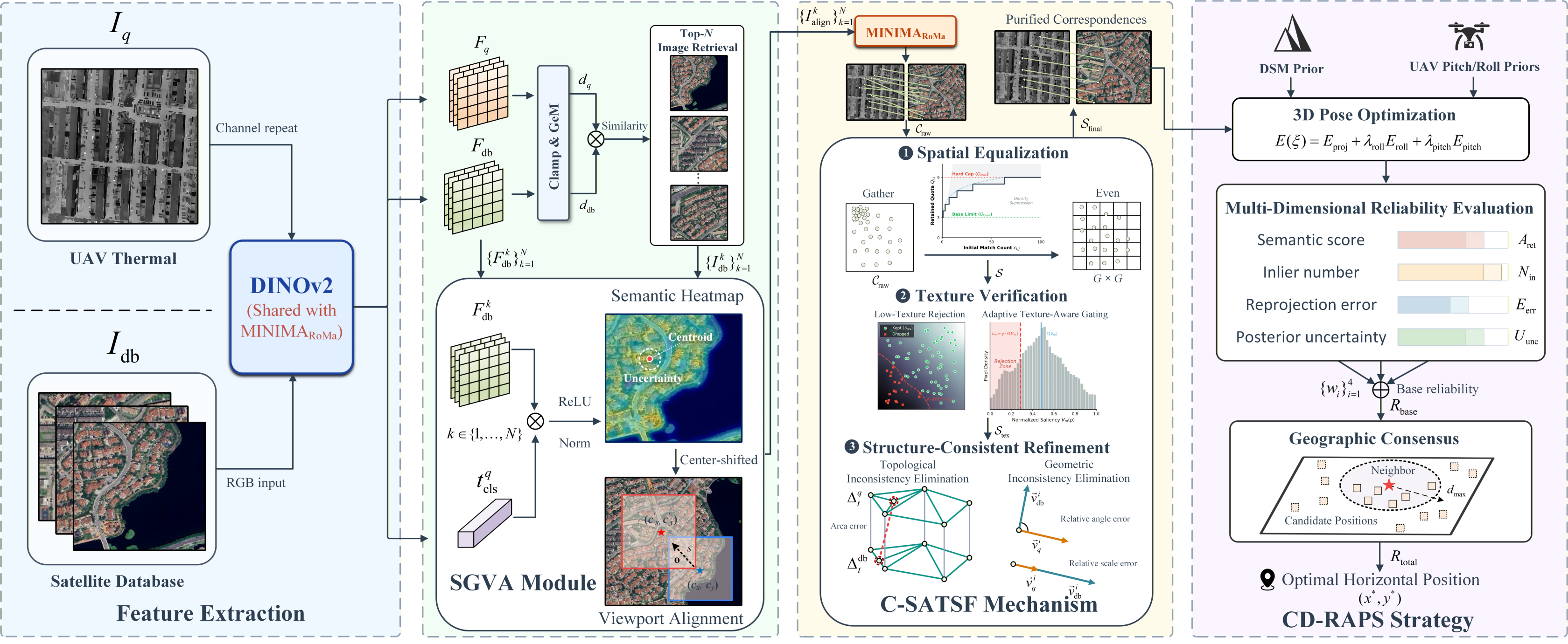
🎯 SCC-Loc is a zero-shot, cross-modal thermal geo-localization framework for UAVs operating in GNSS-denied environments. Matching onboard thermal images with visible-light satellite maps is challenging due to the massive modality gap. SCC-Loc tackles this by providing highly accurate absolute pose estimation without needing domain-specific training .
✨ Key Highlights:
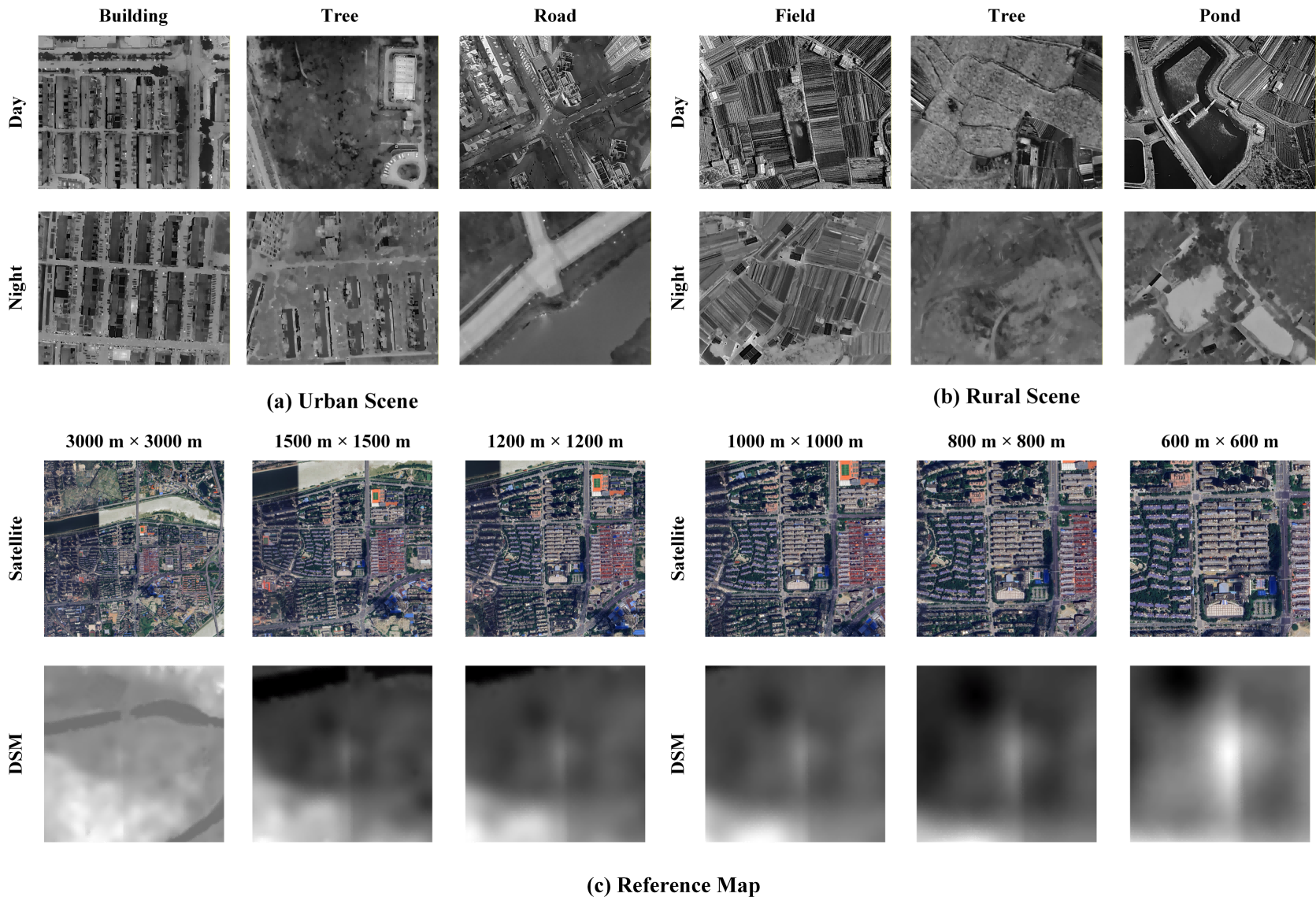
🀄 We constructed the Thermal-UAV dataset, comprising 11,890 thermal UAV images captured using a DJI Matrice 4T drone around Changsha. These images feature nadir views, multi-temporal and multi-scenario data, and continuous flight sequences. We split the dataset into three sets: 8,115 for training, 1,425 for validation, and 2,350 for testing. Additionally, we collected corresponding Google Maps satellite imagery at 0.26 m/px and a Digital Surface Model (DSM) at 5.29 m/px. The directory structure of the Thermal-UAV dataset is as follows:
Data/
├── metadata/
│   ├── train_Thermal.json
│   ├── valid_Thermal.json
│   └── test_Thermal.json
├── Reference_map/
│   └── changsha/
│       ├── ref.tif
│       └── dsm.tif
└── Thermal-UAV/
  ├── train/
  │   └── changsha/
  │       └── <NUDT>/
  │           └── Thermal/
  │               ├── xxx1.JPG
  │               ├── xxx2.JPG
  |	          └──  Thermal_info.csv
  │       └── ...
  ├── valid/
  └── test/
The Thermal-UAV dataset and checkpoint are provided in Baidu Netdisk and Hugging Face. You can use the process.ipynb to get the metadate of Thermal-UAV JSON format, as follows:
{
  "name": "./Data/Thermal-UAV/train/changsha/city_300_ortho_night/Thermal/xxx_T.JPG",
  "lat": 28.2436611, # latitude
  "lon": 112.9985009, # longitude
  "abs_height": 341.354, # absolute height
  "rel_height": 323.967, # UAV-to-ground distance measured by laser rangefinder (direct use this character due to the vertical angle of view)
  "pitch": -90.0, # pitch
  "yaw": 88.0, # yaw
  "roll": 180.0, # roll
  "cam_size": 9.83, # diagonal physical size of the sensor
  "focal_len": 12.0, # focal length (mm)
  "width": 1280.0, # image width
  "height": 1024.0 # image height
}
It is noted that we need to fill in the corresponding changsha geographic infomation in Regions_params/, as follows:
changsha_UTM_SYSTEM: 49N
changsha_SAMPLE_INTERVAL: 10
changsha_HIGH_REF_PATH: ./Data/Reference_map/changsha/ref.tif
changsha_HIGH_DSM_PATH: ./Data/Reference_map/changsha/dsm.tif
changsha_HIGH_REF_initialX: 694811.4577 # UTM coordinate
changsha_HIGH_REF_initialY: 3130673.6615 # UTM coordinate
changsha_HIGH_REF_resolution: 0.3 # Align the resolution through upsampling on QGIS
changsha_HIGH_DSM_resolution: 0.3 # Align the resolution through upsampling on QGIS
changsha_HIGH_REF_COORDINATE: # If the satellite image and DSM are aligned. Their offset is 0
  - 0.0
  - 0.0
changsha_HIGH_DSM_COORDINATE:
  - 0.0
  - 0.0
Retrieval_Models/
└── CAMP/
  └── weights/
    └── weights_0.9446_for_U1652.pth
Matching_Models/
└── RoMa/
    └── ckpt/
        ├── roma_outdoor.pth
        └── dinov2_vitl14_pretrain.pth
Matching_Models/
└── MINIMA/
    └── weights/
        ├── minima_eloftr.pth
        ├── minima_roma.pth
        ├── minima_loftr.ckpt
        ├── minima_lightglue.pth
        └── minima_xoftr.ckpt
In config.yaml, choose the MINIMA_Roma_DINOv2 as retrieval method and MINIMA_Roma as matching method. Our proposed SCC-Loc framework composes this combination. It is noted that when use MINIMA_Roma_DINOv2, it must use MINIMA_Roma, while the reverse is not true. Other combinations can be the comparision baseline.
Then, enjoy the fun of operation through:
python Baseline.py
If you want to see the visualization, please set the SHOW_RETRIEVAL_RESULT=True in config.yaml. It will show retrieval, matching, final localization resules etc.
🚀 Furthermore , process.ipynb provides useful scripts for constructing custom datasets and reproducing experimental results. Given the current strict regulations and flight restrictions on UAVs , we warmly invite researchers dedicated to thermal geo-localization to contribute to this open-source dataset, expanding its coverage to encompass diverse countries, regions, environments, and viewpoints .
If you find this code or our Thermal-UAV dataset useful for your research, please consider citing our paper:
@article{zhang2026scc,
  title={SCC-Loc: A Unified Semantic Cascade Consensus Framework for UAV Thermal Geo-Localization},
  author={Zhang, Xiaoran and Liu, Yu and Liang, Jinyu and Li, Kangqiushi and Huang, Zhiwei and Xiao, Huaxin},
  journal={arXiv preprint arXiv:2604.03120},
  year={2026}
}
We use the Apache License 2.0. See detailed information in LICENSE file.
We are grateful for the publicly available resources and open-source libraries that have been instrumental in this work.
We are especially grateful to Yibin Ye et al. for their seminal benchmark Exploring the best way for UAV visual localization under Low-altitude Multi-view Observation Condition: a Benchmark
Thank you for your open-source spirit, which has significantly accelerated progress in the UAV visual geo-localization community. Salute to you!
If you find our work useful, please consider giving us a ⭐️. Your support means a lot to us! 🥰
🎯 SCC-Loc is a zero-shot, cross-modal thermal geo-localization framework for UAVs operating in GNSS-denied environments. Matching onboard thermal images with visible-light satellite maps is challenging due to the massive modality gap. SCC-Loc tackles this by providing highly accurate absolute pose estimation without needing domain-specific training .
✨ Key Highlights:
🀄 We constructed the Thermal-UAV dataset, comprising 11,890 thermal UAV images captured using a DJI Matrice 4T drone around Changsha. These images feature nadir views, multi-temporal and multi-scenario data, and continuous flight sequences. We split the dataset into three sets: 8,115 for training, 1,425 for validation, and 2,350 for testing. Additionally, we collected corresponding Google Maps satellite imagery at 0.26 m/px and a Digital Surface Model (DSM) at 5.29 m/px. The directory structure of the Thermal-UAV dataset is as follows:
Data/
├── metadata/
│   ├── train_Thermal.json
│   ├── valid_Thermal.json
│   └── test_Thermal.json
├── Reference_map/
│   └── changsha/
│       ├── ref.tif
│       └── dsm.tif
└── Thermal-UAV/
  ├── train/
  │   └── changsha/
  │       └── <NUDT>/
  │           └── Thermal/
  │               ├── xxx1.JPG
  │               ├── xxx2.JPG
  |	          └──  Thermal_info.csv
  │       └── ...
  ├── valid/
  └── test/
The Thermal-UAV dataset and checkpoint are provided in Baidu Netdisk and Hugging Face. You can use the process.ipynb to get the metadate of Thermal-UAV JSON format, as follows:
{
  "name": "./Data/Thermal-UAV/train/changsha/city_300_ortho_night/Thermal/xxx_T.JPG",
  "lat": 28.2436611, # latitude
  "lon": 112.9985009, # longitude
  "abs_height": 341.354, # absolute height
  "rel_height": 323.967, # UAV-to-ground distance measured by laser rangefinder (direct use this character due to the vertical angle of view)
  "pitch": -90.0, # pitch
  "yaw": 88.0, # yaw
  "roll": 180.0, # roll
  "cam_size": 9.83, # diagonal physical size of the sensor
  "focal_len": 12.0, # focal length (mm)
  "width": 1280.0, # image width
  "height": 1024.0 # image height
}
It is noted that we need to fill in the corresponding changsha geographic infomation in Regions_params/, as follows:
changsha_UTM_SYSTEM: 49N
changsha_SAMPLE_INTERVAL: 10
changsha_HIGH_REF_PATH: ./Data/Reference_map/changsha/ref.tif
changsha_HIGH_DSM_PATH: ./Data/Reference_map/changsha/dsm.tif
changsha_HIGH_REF_initialX: 694811.4577 # UTM coordinate
changsha_HIGH_REF_initialY: 3130673.6615 # UTM coordinate
changsha_HIGH_REF_resolution: 0.3 # Align the resolution through upsampling on QGIS
changsha_HIGH_DSM_resolution: 0.3 # Align the resolution through upsampling on QGIS
changsha_HIGH_REF_COORDINATE: # If the satellite image and DSM are aligned. Their offset is 0
  - 0.0
  - 0.0
changsha_HIGH_DSM_COORDINATE:
  - 0.0
  - 0.0
Retrieval_Models/
└── CAMP/
  └── weights/
    └── weights_0.9446_for_U1652.pth
Matching_Models/
└── RoMa/
    └── ckpt/
        ├── roma_outdoor.pth
        └── dinov2_vitl14_pretrain.pth
Matching_Models/
└── MINIMA/
    └── weights/
        ├── minima_eloftr.pth
        ├── minima_roma.pth
        ├── minima_loftr.ckpt
        ├── minima_lightglue.pth
        └── minima_xoftr.ckpt
In config.yaml, choose the MINIMA_Roma_DINOv2 as retrieval method and MINIMA_Roma as matching method. Our proposed SCC-Loc framework composes this combination. It is noted that when use MINIMA_Roma_DINOv2, it must use MINIMA_Roma, while the reverse is not true. Other combinations can be the comparision baseline.
Then, enjoy the fun of operation through:
python Baseline.py
If you want to see the visualization, please set the SHOW_RETRIEVAL_RESULT=True in config.yaml. It will show retrieval, matching, final localization resules etc.
🚀 Furthermore , process.ipynb provides useful scripts for constructing custom datasets and reproducing experimental results. Given the current strict regulations and flight restrictions on UAVs , we warmly invite researchers dedicated to thermal geo-localization to contribute to this open-source dataset, expanding its coverage to encompass diverse countries, regions, environments, and viewpoints .
If you find this code or our Thermal-UAV dataset useful for your research, please consider citing our paper:
@article{zhang2026scc,
  title={SCC-Loc: A Unified Semantic Cascade Consensus Framework for UAV Thermal Geo-Localization},
  author={Zhang, Xiaoran and Liu, Yu and Liang, Jinyu and Li, Kangqiushi and Huang, Zhiwei and Xiao, Huaxin},
  journal={arXiv preprint arXiv:2604.03120},
  year={2026}
}
We use the Apache License 2.0. See detailed information in LICENSE file.
We are grateful for the publicly available resources and open-source libraries that have been instrumental in this work.
We are especially grateful to Yibin Ye et al. for their seminal benchmark Exploring the best way for UAV visual localization under Low-altitude Multi-view Observation Condition: a Benchmark
Thank you for your open-source spirit, which has significantly accelerated progress in the UAV visual geo-localization community. Salute to you!



